|
|
Post by Franko10 ™ on Nov 29, 2004 8:47:58 GMT -5
99
REPORT ON THE DIAMOND EXPLORATION
POTENTIAL FIVE PROPERTIES IN THE
FORT a la CORNE AREA, SASKATCHEWAN,
ON BEHALF OF
FORT a la CORNE DIAMOND FIELDS INC.
ROBERTSHAW GEOPHYSICS
Saskatoon, SK |
|
|
|
Post by Franko10 ™ on Nov 29, 2004 8:53:13 GMT -5
|
|
|
|
Post by Franko10 ™ on Nov 29, 2004 8:57:55 GMT -5
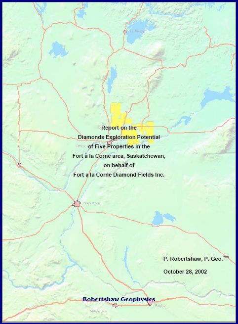
Report on the
Diamonds Exploration Potential
of Five Properties in the
Fort à la Corne area, Saskatchewan,
on behalf of
Fort a la Corne Diamond Fields Inc.
P. Robertshaw, P. Geo.
October 28, 2002
Robertshaw Geophysics
i
SUMMARY
During 2001 and 2002, a land position totaling 247 708 ha has been assembled by a group of 5
companies in the Fort à la Corne kimberlite exploration area of central Saskatchewan. The
dispositions are adjacent to the 74 known kimberlite bodies of the Fort à la Corne kimberlite
field, where the Cameco/De Beers/Kensington Joint Venture and Shore Gold Inc. are currently
engaged in advanced evaluation programs.
The Fort à la Corne area kimberlites were discovered in a surge of exploration work beginning
in 1988. Aeromagnetic surveys were used extensively as a cost-effective exploration tool, and
the moderately- to strongly-magnetic kimberlite bodies were outlined rapidly. Exploration
declined after 1995 when it appeared that uneconomic diamond grades were being encountered
in drilling, particularly in comparison to the spectacularly high grades being reported at that time
from exploration programs in NWT from areas which are currently the Ekati and Diavik mining
camps. The last Fort à la Corne area kimberlite discovery (the small and weakly magnetic
Smeaton kimberlite body) was drill tested in 1996. Several other weak aeromagnetic anomalies
in the general area were found to be caused by sources other than kimberlite, but many remain
untested.
The geological framework of kimberlite emplacement and the present architecture of typical Fort
à la Corne kimberlites are reviewed. Structures in the Sask craton Archean basement are
proposed, which may have affected the localization of the 74 kimberlite bodies located to date.
These structures and trends might be used to focus further exploration.
As the kimberlite bodies are generally covered by approximately 100 m of glacial overburden,
with no surface expressions or geochemical indicator mineral dispersion trains, exploration has
relied heavily on geophysical methods. The application and effectiveness of various
geophysical methods is reviewed. Airborne and ground magnetics have been used widely, and
all of the known kimberlite bodies have been located through follow-up of magnetic anomalies.
Gravity, resistivity, airborne EM, EM depth soundings and high resolution reflection seismic
profiling have been tested over some targets and found to be effective, though more costly.
Several high quality aeromagnetic surveys have been completed over portions of the 5 Fort à la
Corne area properties, with some ground follow-up including drilling, in the public record. The
results of aeromagnetic surveys covering approximately 87% of the claims are available in map
form, while digital aeromagnetic data are available for a smaller region.
A multi-phase program of exploration is proposed for the properties of interest to Fort a la Corne
Diamond Fields Inc. This should commence with an analysis of the available high quality public
domain aeromagnetic coverage for any magnetic features which might not have been
adequately investigated. Geophysical screening (gravity or resistivity surveys) of any
prospective anomalies would be followed by drill testing, if warranted. The search for possible
non-magnetic kimberlite bodies would begin with systematic airborne resistivity mapping using
the GeoTem EM system. This would be followed by screening of prospective anomalies, using
gravity and ground EM/resistivity surveys, and ultimately by drill testing.
|
|
|
|
Post by Franko10 ™ on Nov 29, 2004 8:59:05 GMT -5
Statement of Qualifications
I, Philip Robertshaw, of Saskatoon, Saskatchewan, do hereby certify that:
♦ I am a consulting geophysicist with an office located at 111 Middleton Crescent
Saskatoon, Saskatchewan, S7J 2W5
♦ I am a graduate of the University of London, UK, with B.Sc (Honours) in Physics (1969), and
M.Sc. in Geophysics (1970), and have been engaged in mineral exploration continuously since
1970.
♦ I am a member of:
�� Professional Engineers and Geoscientists of Saskatchewan, with
Permission to Consult
�� Society of Exploration Geophysicists
�� Geological Society of Canadian Institute of Mining
�� Prospectors and Developers Association of Canada
�� Geological Association of Canada
♦ I am the author of this report, which is based on fieldwork on portions of the properties and
surrounding properties since 1988, publicly available information in Saskatchewan Industry and
Resources Open Files, peer-reviewed publications, and news releases by companies active in
exploration within this area. Although the information supplied to me and assembled by me is
believed to be accurate, and all reasonable care has been taken in the completion of this report, I
hereby disclaim any and all liability arising out of its use or circulation. While I stand behind my
interpretations, I cannot guarantee the accuracy of the source information therefore the use of this
report or any part thereof shall be at the user’s sole risk.
♦ I have been involved with kimberlite exploration in the Fort à la Corne area since 1988, in the
position of Chief Geeophysicist with Uranerz Exploration and Mining Limited from 1988 to
1998, and since 1998 as a consulting geophysicist.
♦ As a result of my experience and qualifications, I am a Qualified Person as defined in National
Instrument 43-101.
♦ I have no direct or indirect interest in the properties discussed in this report, or in the securities of
Fort à la Corne Diamond Fields Inc., nor do I expect to receive any.
♦ Permission is hereby granted to use this document as a technical report for the purpose of a
private or public financing, or for other such suitable purpose. My written permission is required
for the release of any summary or excerpt.
Dated and Sealed at Saskatoon, Saskatchewan this 28th day of October, 2002.
PROFESSIONAL SEAL
______________________________
Philip Robertshaw, M.Sc., P.Geo.
ii
TABLE OF CONTENTS
1 Introduction and Terms of Reference................................................................................... 1
2 Disclaimer........................................................................................................................... 1
3 Property Description and Location ....................................................................................... 2
3.1 Tenure.......................................................................................................................... 2
3.2 Other Regulations Governing Mineral Dispositions........................................................ 2
3.3 Current Mineral Disposition Status ................................................................................ 3
4 Accessibility, Climate, Local Resources, Infrastructure and Physiography ........................... 4
5 History ................................................................................................................................ 5
5.1 Diamonds exploration in Central Saskatchewan............................................................ 5
5.1.1 Sturgeon Lake......................................................................................................... 5
5.1.2 Fort à la Corne........................................................................................................ 5
5.1.3 Candle Lake............................................................................................................ 6
5.1.4 Shore Gold (Star kimberlite).................................................................................... 6
5.1.5 Smeaton ................................................................................................................. 7
5.1.6 Foxford.................................................................................................................... 7
5.1.7 Snowden South....................................................................................................... 7
5.1.8 Diamond-related Exploration Expenditures ............................................................. 8
5.2 Prior Exploration Work within the 5 Properties of Interest .............................................. 8
5.2.1 Aeromagnetic Surveys ............................................................................................ 9
5.2.2 Ground Magnetometer Surveys ............................................................................ 10
5.2.3 Drilling................................................................................................................... 11
|
|
|
|
Post by Franko10 ™ on Nov 29, 2004 8:59:17 GMT -5
5.2.4 Drilling Results from the Snowden Kimberlites ...................................................... 13 6 Geological Setting.............................................................................................................. 15 6.1 Basement Geology..................................................................................................... 15 6.2 Crustal Structures........................................................................................................ 16 6.3 Phanerozoic Geology .................................................................................................. 17 6.4 Kimberlite Emplacement and Architecture ................................................................... 17 7 Deposit Types.................................................................................................................... 18 7.1 Economic Considerations............................................................................................ 18 7.1.1 Results from the FalC JV ...................................................................................... 18 7.1.2 Results from the Shore Gold Star Kimberlite......................................................... 20 7.1.3 Results from the Candle Lake JV.......................................................................... 21 8 Other Relevant Data and Information................................................................................. 21 8.1 Magnetics.................................................................................................................... 21 8.2 Gravity........................................................................................................................ 22 8.3 Resistivity .................................................................................................................... 23 8.4 Geotem Airborne Resistivity ........................................................................................ 23 8.5 TEM In-loop Soundings ............................................................................................... 24 8.6 Seismic Reflection Surveys ......................................................................................... 24 9 Interpretation and Conclusions........................................................................................... 24 10 Recommendations.......................................................................................................... 25 11 References ..................................................................................................................... 27 iii LIST OF FIGURES Figure 1: Property Location Map, Scale 1:6 000 000. Figure 2: Diamonds Exploration Properties, Prince Albert-Nipawin area, October, 2002. Scale 1:800 000. Figure 3: Fort à la Corne area properties, Eastern claims, October, 2002. Scale 1:200 000. Figure 4: Fort à la Corne area properties, Western claims, October, 2002. Scale 1:200 000. Figure 5: Aeromagnetic Surveys in SIR Open Files, Fort à la Corne area. Scale 1:500 000. Figure 6: Exploration Drillholes and Ground Magnetometer Surveys in SIR Open Files, Fort à la Corne area. Scale 1:500 000. Figure 7: Kimberlite bodies and drill hole locations in the Snowden area. Scale 1:100 000. Figure 8: Aeromagnetics with major lithotectonic features of the Precambrian basement. Scale 1:6 000 000. Figure 9: Basement structures interpreted from regional aeromagnetics, Prince Albert –<br>Nipawin area. Scale 1:500 000. Figure 10: Phanerozoic stratigraphy in the Fort à la Corne area. Figure11: Cretaceous stratigraphy with kimberlite emplacement intervals and marine transgression – regression cycles. Figure 12: Multi-layered kimberlite body. Figure 13: 2002 Exploration Proposal, Fort à la Corne area. Scale 1:500 000. LIST OF TABLES Table 1: Properties of interest ………………………………………………………………...…1 Table 2: Initial assessment requirements.…………………………………………………...…2 Table 3: Historic kimberlite exploration expenditures in Saskatchewan ………………..…6 Table 4: Aeromagnetic surveys in SEM Open Files ………………………………………..11 Table 5: Ground magnetometer surveys in SEM Open Files ………………………………13 Table 6: Snowden area drill holes (Fort à la Corne JV) in SIR Open Files LIST OF APPENDICES Appendix 1: Listing of Fort à la Corne area claims held by: Buckshot holdings Ltd. (50%) and Commando Holdings Ltd (50%) 101010307 Saskatchewan Ltd. 101012190 Saskatchewan Ltd. 101027101 Saskatchewan Ltd. Morgain Minerals Inc. 1 1 Introduction and Terms of Reference
This report is prepared on behalf of Fort a la Corne Diamond Fields Inc., and is intended to
document the status of kimberlite exploration activities in and around 5 properties which are
located within the Fort à la Corne kimberlite field of central Saskatchewan. The 5 properties
consist of 636 mineral claims with a total area of 247 708 ha (611 625 acres), which are
currently wholly owned by others, as listed in Table 1.
Table 1: Properties of interest
Registered Owner Number of Claims Area (ha) Recording Date
Buckshot Holdings Ltd. (50%)
Commando Holdings Ltd. (50%) 318 78 177 March 2 and 9, 2001
101010307 Saskatchewan Ltd. 142 70 427 May 11, 2001
101012190 Saskatchewan Ltd. 106 81 568 August 16, 2001
101027101 Saskatchewan Ltd. 34 8 320 March 20, 2002
Morgain Minerals Inc. 36 9 216 March 20, 2002
No exploration work has been conducted on the 5 properties by the present owners. There are
no known kimberlite occurrences within the 5 properties, but all are reasonably proximal to the
74 known kimberlite bodies of the Fort à la Corne kimberlite field. The geological setting and
geophysical exploration characteristics of the Fort à la Corne area are discussed, providing a
framework to assess the prospectivity of the properties for further kimberlite discoveries.
The author has conducted and supervised exploration for kimberlites in the Fort à la Corne area
since 1988, is familiar with the areas presently held under claim, and has visited and worked in
portions of these areas during that period. Since kimberlites in this area are covered by 75 m to
150 m of overburden and have no surface expression, an additional field visit for the purpose of
compiling this report was considered unnecessary.
This report draws on compilations by the author of prior kimberlite exploration work (largely
geophysical surveys and drilling) in the Fort à la Corne area, as available in the public domain.
Sources of information are Saskatchewan Industry and Resources (SIR) Open File technical
reports, peer reviewed publications and news releases by publicly traded companies active in
the area.Diamond recoveries and evaluations from adjacent properties, reported by the Cameco/De Beers/Kensington JV, by Shore Gold Inc., and the Candle Lake JV, as available in Open File reports and news releases, are also discussed. 2 Disclaimer SIR requires that interpretive, technical reports must be filed to demonstrate the fulfillment of annual assessment expenditures to maintain dispositions in good standing. These reports (assessment reports) do not necessarily comply with National Instrument 43-101 standards and do not necessarily represent the entire amount of exploration work performed. Though diamond recoveries from Fort à la Corne area kimberlite bodies are noted where relevant, their economic significance is beyond the intended scope of this report. 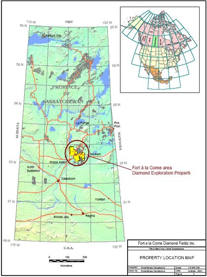 |
|
|
|
Post by Franko10 ™ on Nov 29, 2004 9:00:22 GMT -5
3 Property Description and Location
The 5 parcels of mineral dispositions of interest to Fort a la Corne Diamond Fields Inc. were
registered between March, 2001, and March, 2002, as listed in Table 1. In aggregate, the
claims comprise a substantial and largely contiguous land position in a favourable exploration
setting in the vicinity of the Fort à la Corne kimberlite bodies. In all, the 5 properties consist of
636 claims with a total area of 247 708 ha (611 625 acres). A complete listing of the claims,
areas, ownerships and recording dates is attached as Appendix 1.
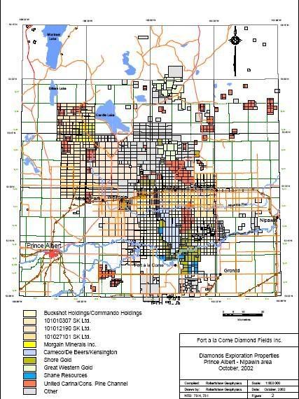
The 5 properties are located in central Saskatchewan (Figure 1), within 100 km of the City of
Prince Albert, and are largely accessible by road. The individual properties are identified in
Figure 2 (1:800 000 scale), in relation to other exploration holdings within the Fort à la Corne
area. In Figures 3 and 4 (1:200 000 scale), the individual claims are further identified. For
reference, the outlines of the known kimberlite occurrences are shown in Figures 3 and 4.
3.1 Tenure
Saskatchewan mineral dispositions are administered by Saskatchewan Industry and Resources
(SIR). The 5 properties fall entirely within the surveyed portion of the province and require an
annual exploration expenditure of $12 per hectare, after the first year, to remain in good
standing. Claim holders must submit evidence of allowable expenditures, or post a deficiency
payment or bond in lieu, within 90 days of the anniversary date.
The initial assessment amounts and due dates for the 5 properties are listed in Table 2.
Table 2: Initial assessment requirements
Registered Owner Area (ha) Due Date Amount
Buckshot Holdings Ltd. (50%)
Commando Holdings Ltd. (50%) 78 177 March 2 and 9, 2003 $938 124
101010307 Saskatchewan Ltd. 70 427 May 11, 2003 $845 124
101012190 Saskatchewan Ltd. 81 568 August 16, 2003 $978 816
101027101 Saskatchewan Ltd. 8 320 March 20, 2004 $99 840
Morgain Minerals Inc. 9 216 March 20, 2004 $110 592
During the 2003 calendar year, expenditures of $2 762 064 will be required to retain the claims.
In 2004 and subsequent years (until 2012) the required assessment expenditure will be
$2 972 496.
3.2 Other Regulations Governing Mineral Dispositions
Claims are defined in terms of legal sections or subdivisions. Road allowances, typically 20 m
in width, fall between sections and are separate legal entities. In November, 2001,
Saskatchewan Energy and Mines (now SIR) amended the description of mineral claims in the
surveyed portion of the province to allocate road allowances to adjacent claim holders so that
claim coverage can be seamless.
After ten years the annual expenditure requirement increases to $25 per hectare. Grouping of
contiguous claims is allowed to a maximum block size of 10 000 hectares. Reports submitted in
support of assessment filings are held confidential by SIR for a period of 3 years, or until the
claims lapse if earlier.
|
|
|
|
Post by Franko10 ™ on Nov 29, 2004 9:03:36 GMT -5
|
|
|
|
Post by Franko10 ™ on Nov 29, 2004 9:06:02 GMT -5
|
|
|
|
Post by Franko10 ™ on Nov 29, 2004 9:06:50 GMT -5
|
|
|
|
Post by Franko10 ™ on Nov 29, 2004 9:07:07 GMT -5
3.3 Current Mineral Disposition Status
The competitive mineral property status of the Fort à la Corne area, as of October 1, 2002, is
shown in Figure 2. The core property which contains 63 confirmed kimberlite occurrences is
held by the Fort à la Corne (FalC) JV of Cameco/De Beers/Kensington, and has been
maintained in good standing since the claims were acquired in 1988 and 1989. The JV
currently holds 121 claims for a total of 22 544 ha. During 2001, the FalC JV sold 3 outlying
blocks of claims containing 5 drill-confirmed kimberlite bodies located in the northern part of the
trend, to Shore Gold Inc. The blocks are located near Weirdale (4 claims, 1024 ha in area,
containing 2 kimberlite bodies), near Foxford (12 claims, 1088 ha in area, also containing 2
kimberlite bodies) and east of Birchbark Lake (5 claims, 320 ha in area, containing 1 kimberlite).
Shore Gold Inc. have progressively increased their land holdings by staking around the margin
of the Fort à la Corne area since 1995, in addition to the above mentioned purchases in the
north part of the area. Shore Gold currently hold 125 claims with a total area of 28,432 ha.
Shore’s Star Kimberlite body, which seems to be one of the more prospective kimberlites of the
district, is located at the southeastern end of the Fort à la Corne kimberlite trend. One other
small kimberlite body is located on Shore claims to the east of the Star kimberlite. Shore’s
inventory of kimberlites (8 in all) consists of the 2 bodies at the southern end of the trend,
together with the 5 kimberlites purchased from the FalC JV and a small body located near
Foxford. Skeena Resources Ltd. hold an option to earn 70 % of the Weirdale, Foxford and
Birchbark Lake properties.
United Carina Resources Corp. and Consolidated Pine Channel Gold Corp. had sizeable
exploration programs during the 1993-94 period, which included over 55 drill holes in the
Montreal Lake – Wapawekka Lake area to the north, and the Torch River area east of Fort à la
Corne. They have recently renewed their kimberlite exploration programs by acquiring sizeable
properties in the wider Fort à la Corne area (January 2000) and claims adjacent to the
Cameco/De Beers/Kensington kimberlite 122 (with Shane Resources, November, 2000) on the
west side of the main kimberlite cluster. Notable properties are the Smeaton claim block
(10 624 ha) which contains a drill tested kimberlite body, and the ‘Diamond Lady’ claim block
which adjoins the east side of the main FalC JV property. United Carina and Consolidated Pine
Channel currently hold 57 323 hectares in 267 claims. In 2002, PanTerra Exploration Corp.
entered into option agreements to acquire a 60% interest in the Smeaton and ‘Diamond Lady’<br>claim blocks.
I
psco, who maintain claims in the vicinity of their 1950’s iron ore exploration project (the
Choiceland iron deposit), have modestly persued diamonds exploration south of Choiceland
since 1989. Ipsco recently added to their dispositions, mainly extending further to the east of
the main Fort à la corne kimberlite cluster, and now control 79 largely contiguous claims
covering 8795 hectares.
Successor companies of Rhonda Mining, formerly a major participant, now hold 5 claims east of
the Fort à la Corne main cluster and 1 small claim south of the Saskatchewan River, a total of
1088 hectares. Claude Resources, also a major participant during the mid ’90’s, is currently
reduced to holding 1 claim (256 ha).
I
n December, 2001, Twin Oaks Management staked a 30 claim property (24 736 ha) near
Foxford and northeast of Birchbark Lake.
Currently, an area in excess of 100 km north-south x 80 km east-west, centred on the
Cameco/De Beers/Kensington Fort à la Corne dispositions, is almost completely staked.
|
|
|
|
Post by Franko10 ™ on Nov 29, 2004 9:07:29 GMT -5
4 Accessibility, Climate, Local Resources, Infrastructure and Physiography
The property lies between 25 km and 100 km east and northeast of the City of Prince Albert,
population 42,000, which is served by road, rail and scheduled air links. Provincial Highway 55
and a single track Canadian Pacific rail line, which link Prince Albert and the town of Nipawin,
traverse the properties between Meath Park and Choiceland (Figure 2). A series of villages of
which Smeaton (population 220) is the largest, are located along Highway 55. Paved Highway
120 (Meath Park to Candle Lake) and subsidiary roads provide access to the western portion of
the properties. Highway 6, linking Melfort and Choiceland, is located on the east side of the
claims. Highway 302 provides access to claims south of the North Saskatchewan River. A
network of unpaved grid roads covers the agricultural belt which lies between the White Fox
River and Highway 55, and extends irregularly north of Highway 55. Towards the west, farm
land served by grid roads extends as far as 55 km north of Prince Albert. This is the northern
limit of arable agriculture in this region of the province. Approximately 150,000 ha (60 %) of the
combined disposition areas fall within agicultural land.
The Fort à la Corne Provincial Forest occupies non-agricultural land between the White Fox
River and the Saskatchewan River. North of Highway 55, most of the non-agricultural land is
classified as Northern Provincial Forest. Some forest fringe areas are classified as
underdeveloped Crown Lands and certain areas are subject to wildlife habitat regulations.
Access within the forested areas is provided by a network of logging roads and 4WD trails.
This region of the province falls within the boreal transition ecoregion which defines the
gradation from the grasslands and aspen groves of the south to the true boreal forest of the
north. Both the Fort à la Corne Provincial Forest and this region of the Northern Provincial
Forest are generally mature forest, with a predominance of jack pine. Aspen, alder, white and
black spruce, poplar and tamarack are found in local stands.
The terrain is flat except for the deeply incised flanks of the North and South Saskatchewan
River valleys in the south and an area of sand dunes in the southeastern part of the properties,
near Highway 6. Elevations within the properties range from 450 m to 550 m ASL, rising gently
towards the northwest. The highest elevations are found to the southwest of Candle Lake,
within the Northern Provincial Forest.
Climate data have recently been compiled by the University of Saskatchewan Geography
Department as part of the Atlas of Saskatchewan project (1999). The climate of the Prince
Albert region is described as humid continental, cool summers (Köppen temperature and
precipitation classification). The annual mean temperature (100 year average) is 0.8°C.<br>Monthly mean temperatures vary from -19°C (January) to +17°C (July). The average annual
number of hot days (30°C or higher) is 6. The average annual number of very cold days
(-30°C or lower) is 29. The annual mean precipitation is 406 mm, with precipitation (0.2 mm or
greater) in 21 days per year, on average.
The uranium and gold mining operations of northern Saskatchewan are serviced in part by
Prince Albert area businesses, and draw skilled labour form this area. Electrical power is
generated nearby (the E.B. Campbell Hydro Generating Station on the Saskatchewan River
west of Nipawin) and telecommunications infrastructure is in place.
5
5 History
5.1 Diamonds exploration in Central Saskatchewan
5.1.1 Sturgeon Lake
The presence of kimberlite in Saskatchewan was unknown until Monopros, the Canadian
subsidiary of De Beers, discovered an exposure during a regional prospecting program in 1987.
The kimberlite was found in a gravel pit located in a terrace on the north shore of Sturgeon
Lake, some 35 km northwest of Prince Albert. The find came to the attention of local
prospectors in 1988 when Monopros set up a bulk processing plant at the site, and rumours
began to circulate in the exploration community. Since kimberlites often cause magnetic
anomalies, several companies conducted aeromagnetic surveys in the vicinity during the
summer of 1988, and a number of anomalies were discovered within a few kilometers of
Sturgeon Lake. The activity resulted in a considerable amount of staking.
The Sturgeon Lake body ultimately proved to be a glacially transported raft of kimberlite
measuring about 180 m x 110 m and 10 to 20 m thick, and underlain by about 40 m of
overburden. In a 1988 ground magnetometer survey reported by Monopros (SIR Open File
73G08-0001), the Sturgeon Lake kimberlite is represented by an oval mag high with a peak
value of 1700 nT above background.
Monopros processed 226 m3 of kimberlite from 11 trenches on this body in 1988, and shipped a
heavy mineral concentrate to their Thunder Bay laboratory. A few microdiamonds were
recovered, but no macrodiamonds were reported. Monopros and others (Claude Resources,
Corona Corp., Cameco Corp., Rhonda Mining Corp.) drilled additional targets of this type in the
Sturgeon Lake area between 1989 and 1993, with mixed success. At least two smaller, rafted
kimberlite blocks were confirmed, although no diamond recoveries are reported. All the
Sturgeon Lake area claims were subsequently allowed to lapse. The original gravel pit
exposure of kimberlite was restaked in May, 2000. An in situ source for the glacially transported
Sturgeon Lake kimberlite blocks has not been identified.
5.1.2 Fort à la Corne
During the 1988 staking rush, Uranerz Exploration and Mining acquired a large land position in
the Fort à la Corne Forest area, some 60 km east of Prince Albert. The ground was chosen on
the basis of aeromagnetic anomalies which were thought to resemble kimberlite-type targets, in
the available GSC (1960’s era) regional aeromagnetic coverage. Twenty eight isolated contour
highs were identified and staked. Subsequently, a detailed aeromagnetic survey of the area in
1989 revealed 73 prominent magnetic anomalies, of which 71 have so far been proven to be
caused by kimberlite bodies (Lehnert-Thiel et al., 1992, Jellicoe et al, 1998).
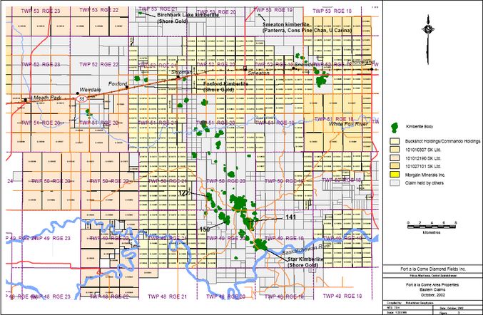
The main group of kimberlites is located within the Fort à la Corne Provincial Forest and forms a
north-northwest elongated cluster approximately 32 km in length, extending from the
Saskatchewan River to Highway 55 near Shipman, as shown in Figure 3. Smaller outlying
kimberlite clusters occur near Weirdale in the west, near Foxford in the north and near Snowden
in the northeast. The kimberlite bodies are grouped more densely in the south, and spaced out
more irregularly towards the north. A grouping of very large kimberlite bodies occurs in the
southern part of the trend, as shown in Figure 3.
The sizes of the kimberlite bodies have been estimated from geophysical models, which
indicate a range of 2.7 to 184 hectares. The mass of kimberlite at each body has also been
estimated, using a conservative density value of 2.5 gm/cc, and ranges from 3 to 675 million
|
|
|
|
Post by Franko10 ™ on Nov 29, 2004 9:08:09 GMT -5
tonnes. The cumulative kimberlite footprint area for the 71 bodies held by the FalC JV in 1998
was estimated to be 2818 hectares, and the total mass of kimberlite was estimated at 9.5 billion
tonnes (Jellicoe et al., 1998).
The Fort à la Corne Joint Venture between Uranerz and Cameco was formed in 1989.
Monopros (now De Beers) joined the JV in 1992, followed by Kensington Resources in 1995. In
1998, Uranerz was acquired by Cameco. According to an October 15, 2002, news release by
Kensington Resources, the project ownership is currently Cameco (15.5%), De Beers (42.25%)
and Kensington (42.25%). The Cameco/De Beers/Kensington land holding currently (October,
2002) consist of 22 544 hectares in 121 claims.
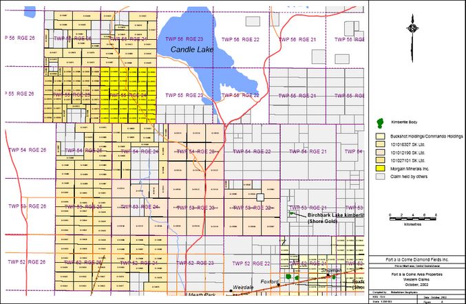
5.1.3 Candle Lake
In 1993, War Eagle Mining Co. and Great Western Gold Corp. acquired a block of ground
immediately east of Candle Lake, covering an area approximately 70 km north-south x 60 km
east-west, and beginning 6 km north of the northern-most kimberlite body of the
Cameco/Monopros/Uranerz Fort à la Corne project. Early work by War Eagle and Great
Western Gold included large scale aeromagnetic surveys, follow-up ground magnetometer
surveys and drilling. Three kimberlite bodies (C28, C29 and C30) were intersected in 1994 (SIR
Open File 73I-03-0005). Kennecott Canada optioned the property in early 1995. Further drilling
indicated that bodies C29 and C30 were actually one elongated kimberlite body with a nonmagnetic
central section. The C29/C30 body is estimated to contain in excess of 60 million
tonnes of kimberlite, while body C28 is thought to contain about 6 million tonnes.
A mini-bulk sampling program was completed on the C29/C30 body during the winter of 1998,
with a total of 7.5 tonnes of kimberlite recovered. Diamond recoveries were deemed to be poor
and Kennecott terminated their interest in the Candle Lake property in the fall of 1998 (Great
Western Gold news release, November 26, 1998). The property was inactive until the summer
of 2002 when Great Western Gold completed a drilling program of 3 NQ holes. The current
ownership is Great Western Gold (80%), War Eagle Mining (20%).
5.1.4 Shore Gold (Star kimberlite)
In December, 1995, a Crown Reserve covering the Saskatchewan River valley was released for
staking. The land included two aeromagnetic targets immediately south of the Fort à la Corne
JV claims which were widely known at that time, from numerous aeromagnetic surveys, to be
kimberlite-type targets. The ground was acquired by Shore Gold Inc. and is currently held
100% by Shore Gold. Both features have proven to be kimberlite bodies, and the larger of the
two targets has been named by Shore the ‘Star kimberlite’.
Shore describe the Star kimberlite as over 4 sq km in area (with drill-defined thicknesses of at
least 30 m), with a mass in excess of 400 million tonnes. These figures would place the Star
kimberlite as the largest single kimberlite body in footprint area, and among the top five bodies
in mass, of the Fort à la Corne district. However, as shown in Figure 3, many of the Fort à la
Corne kimberlite bodies are comparable in size but for historical reasons are subdivided.
Applying the Fort à la Corne JV practice, the Star kimberlite might be regarded as 4 or 5
coalesced bodies. Shore’s practice is probably more appropriate as the geological model has
evolved from vertical diatremes to flat-lying crater facies material since the FalC JV numbering
scheme was implemented.
7
5.1.5 Smeaton
A very weak aeromagnetic anomaly was detected 10 km north of Smeaton in 1994 by The
Saskatchewan Diamond Syndicate (Golden News Resources, Laminco Resources and
Swannell Minerals). Golden News/Laminco/Swannell obtained ground mag coverage of the
target in 1995. A 200 m-wide anomaly of 25 nT peak amplitude was located, in agreement with
the aeromagnetic feature. The target was drilled by Laminco, Swannell and Calco Resources in
1996. Hole RS-1 was collared at the centre of the ground mag anomaly and intersected 90.7 m
of kimberlitic material beneath 128.0 m of overburden. The hole ended in sandy mudstones,
possibly Mannville Group sediments, at a depth of 248 m. Four samples of kimberlite core were
tested for microdiamond content by caustic fusion, and none were found. The property was
allowed to lapse in 2000.
D.W. Ventures acquired the ground in June, 2000, and the expanded property is now wholly
owned by United Carina Resources (50%) and Consolidated Pine Channel (50%). In 2000, a
gravity survey was completed, followed by a program of 4 ‘H’ size drill holes. United Carina
subsequently reported that 3 holes reached bedrock and intersected ‘several metres of
subaqueous fragmental and marine worked kimberlite, intercalated with fine grained sediments’.
No microdiamond or indicator mineral results have been released. PanTerra Exploration Corp.
hold an option to acquire 60% of the 30-claim property which includes this kimberlite body.
5.1.6 Foxford
Rhonda Mining intersected 34.5 m of kimberlite in a drillhole 3 km east of Foxford in 1993.
Drillhole OFS93-012 was targeted at a very weak magnetic anomaly derived from a detailed
aeromagnetic survey and subsequently confirmed by ground mag coverage. The kimberlite
intersection occurs in Lower Colorado shales, 70 m below the bedrock surface. Three
microdiamonds were recovered from 20.77 kg of core (SIR Open File 73H06-0003). Two
follow-up holes were drilled by Kensington Resources in 1994. Due to a property ownership
dispute at the time, these were collared in a road allowance 500 m further east and failed to
intersect kimberlite (SIR Open File 73H06-0010). The kimberlite intersection of OFS93-12 is
over 800 m south of two known kimberlite bodies of the Fort à la Corne JV, which are located
north of Highway 55, east of Foxford (as shown in Figure 3).
The kimberlite discovery location was held by Rhonda and later by Kimmswick Diamonds as a
single, small (64 ha) claim, and was allowed to lapse in 1999. The ground was restaked by
Active Engine in February, 2000, and is currently held by Shore Gold.
5.1.7 Snowden South
In 1993, Rhonda Mining staked a group of claims immediately south of the Cameco/De
Beers/Kensington Snowden claim block after a detailed aeromagnetic survey indicated the
possibility of shallow magnetic features extending across the Cameco/De Beers/Kensington
claim boundary. Three drillholes were completed by Rhonda Mining Corp. in 1993, 5 km
southeast of Snowden. All three encountered tuffaceous and detrital kimberlite (thicknesses of
15 m, 9 m and 14 m) at the bedrock surface (approximately 110 m below surface). Indicator
mineral chemistry and microdiamond analyses were performed on kimberlite core samples. A
total of 21 microdiamonds were reported from approximately 100 kg of kimberlite. (SIR Open
File 73H07-0018).
A nearby follow-up drillhole in 1994 (OFS94-017) failed to intersect kimberlite. This hole was
drilled to a final depth of 160.0 m after intersecting the bedrock surface at 112.86 m. The
section containing the Rhonda drillholes, and an adjacent section to the east, is currently held
by Anglo Minerals.
|
|
|
|
Post by Franko10 ™ on Nov 29, 2004 9:08:43 GMT -5
5.1.8 Diamond-related Exploration Expenditures
Annual mineral expenditure figures are compiled by Saskatchewan Industry and Resources.
The expenditures relating to diamonds exploration since 1988 are compiled in Table 3.
Table 3: Historic kimberlite exploration expenditures in Saskatchewan.
Year Estimated Spending
($ Million) Number of Operators Number of Assessment
Submissions
1988 2
1989 2.29 6 9
1990 1.75 7 8
1991 2.67 5 3
1992 4.20 7 10
1993 11.06 20 63
1994 10.14 22 64
1995 3.76 16 11
1996 5.72 13 7
1997 2.39 8 6
1998 1.06 8 1
1999 1.43 8 Subject to 3 yrs confidentiality period
2000 4.11 8 ..
2001 8.56 estimated ..
The surge in exploration activity during 1993 and 1994 was largely driven by the availability of
cheap, high quality aeromagnetic surveys. The southern third of Saskatchewan (south of
latitude 53°N) had virtually no aeromagnetic coverage in the public domain at that time. Also,
the 1960’s era regional GSC aeromagnetic coverage north of 53°N was seen as only partially
effective. Kimberlite discoveries during this period were disappointing, amounted to the 2
bodies at the War Eagle/Great West Gold Candle Lake property, and the two apparently small
kimberlite bodies at Smeaton (Golden News/Laminco/Swannell) and Foxford (Rhonda Mining).
The Snowden south area extension of a Cameco/De Beers/Kensington JV kimberlite was also
outlined (by Rhonda Mining) during 1993-94.
During the mid 1990’s, in response to the high level of industry activity, GSC sponsored a
program of aeromagnetic coverage of southern Saskatchewan. The program was jointly funded
by GSC, the province (SGS) and industry partners. Seven blocks of new (digital) coverage
were obtained and have been released as GSC Open Files. The existing analogue aeromag
data of the 1960’s has been digitized and merged with the new coverage to provide complete
aeromagnetic coverage of the province, as shown in Figure 8.
Between 1997 and 1999, activities at the major Saskatchewan exploration projects declined to a
low level. Kennecott withdrew from the Candle Lake project and activity by junior companies
also subsided. Beginning in 2000, the Cameco/De Beers/Kensington JV and the Shore Gold
projects have renewed and accelerated their exploration programs, although junior company
activity remains weak.
5.2 Prior Exploration Work within the 5 Properties of Interest
No kimberlite exploration work has been performed by the current property owners. Following
are summaries of work performed by prior owners, which has been submitted to Saskatchewan
Industry and Resources in fulfillment of assessment requirements. As such, the reports may not
contain the results of all work actually completed.
9
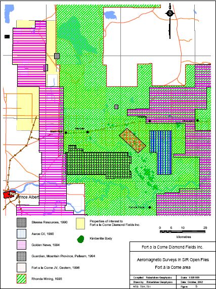
5.2.1 Aeromagnetic Surveys
SIR Open Files contain records of 6 aeromagnetic surveys which have been completed within
and peripheral to the 5 properties of interest. Over 90 % of the properties are covered by
these surveys. The results of each survey are available from SIR as paper prints of total
magnetic field contour maps, and also in most cases as vertical magnetic gradient contour
maps. Digital data files for only one survey, the 1996 Fort à la Corne JV Geotem test survey,
are available from SIR. The aeromagnetic surveys are listed in Table 4, and the corresponding
outlines are shown in Figure 5.
Table 4: Aeromagnetic surveys in SIR Open Files
SIR Open File Company Date of
work Area Survey specs
73-0003 Skeena Resources 1990
Birchbark Lake
Candle Lake #9
Candle Lake
Wolftrap Creek
Small blocks, 300 m line
spacing
73H07-0010 Aaron Oil 1990 South Snowden 1063 line km, 200 m line
spacing
73-0009 Rhonda Mining 1993 Regional
51,600 line km.
150 m, 200 m and 300 m
line spacing.
73H-0004
73H-0005
Golden News 1994
Golden 1, 2, Rebitt
Golden 4, 5, Torch R
5542 line km, 300 m line
spacing.
12,631 line km, 150 & 300
m line spacing.
73H06-0007 Guardian/Mountain
Province/Pallaum 1994 Strong Pine 1714 line km, 200 m line
spacing
73H-0008 Uranerz 1996 Smeaton Geotem test survey
12 km x 4 km block
300 m line spacing
The 1990 work by Skeena Resources involved fixed wing aeromagnetic surveys over four single
claims covering targets picked from GSC regional aeromagnetics. The aeromagnetic surveys
indicated broad mag high features which were interpreted as basement-type signatures. The
targets were not drilled and the claims were allowed to lapse.
The 1993 aeromagnetic coverage by Rhonda Mining consisted of several surveys which were
merged together. Canagrad flew three detailed surveys (150 m and 200 m line spacing) over
the Fort à la Corne JV area, covering most of NTS map sheet 73 H/7 and adjacent ground.
Geoterrex flew a larger survey (with 300 m line spacing) over the surrounding area, extended
particularly towards the east, and also several peripheral blocks. The combined
Canagrad/Geoterrex coverage includes the portion of the properties lying to the east of, and
including Range 23, and comprising 69% (171,000 ha) of the presently held properties. Contour
maps of the combined mag coverage follow NTS sheet outlines at 1:50,000 scale. The survey
results are presented on 38 sheets with both total magnetic field contours and vertical gradient
contours. The Rhonda survey seems to be a high quality data set, and although not available in
the public domain in digital form for further processing, the contour maps are a useful starting
point to search for subtle anomalies.
|
|
|
|
Post by Franko10 ™ on Nov 29, 2004 9:13:06 GMT -5
|
|
|
|
Post by Franko10 ™ on Nov 29, 2004 9:13:40 GMT -5
The 1994 Golden 2 and Rebitt aeromagnetic surveys by Golden News cover a further 20 % of
the properties to the west of Township 23. The flight line spacing for these surveys was 300 m.
Contoured total field and calculated vertical magnetic gradient maps at 1:50 000 scale are
available in SIR Open Files.
Some eastern portions of the properties lie within the Golden 4 survey area, which provides 150
m line spacing coverage. Contoured total field and calculated vertical magnetic gradient maps
at 1:25 000 scale are available in SIR Open Files. The Golden 4 survey detected the weak
anomaly 9 km north of Smeaton which was drilled in 1996 (Laminco/Swannell/Calco Resources)
and found to be caused by kimberlite.
The 1996 Geotem survey by Uranerz (Fort à la Corne JV) included aeromagnetics. The survey
covers 10 known kimberlite bodies, which are all strongly magnetic, within a 12 km x 4 km
block. The aeromagnetic and EM/resistivity data are available in digital form from SIR.
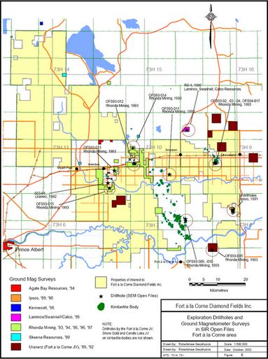
5.2.2 Ground Magnetometer Surveys
SIR Open File records contain 17 reports with details of 34 ground mag surveys which have
been completed since 1889 within and peripheral to the 5 properties. The survey locations are
indicated in Figure 6. The corresponding Open File listings are contained in Table 5.
The Agate Bay and Kennecott surveys (1994 and 1996, respectively) located broad mag
features which were interpreted to be caused by deep magnetic features (> 600 m) which seem
to be related to basement geology.
The 1989 ground mag surveys by Uranerz were tests of broad aeromagnetic features, and all
are described as caused by basement geology in Open File report 73H-0001. The Ipsco
coverage located weak, sinuous magnetic features which were thought to be at bedrock depth
(+/- 100 m), but were not confirmed by drilling, and were likely caused by features in
overburden. Two of the four Skeena surveys were follow-up to single claim-size aeromag
surveys, the remaining two were located on GSC aeromag highs. All four mag features were
subsequently interpreted to be caused by basement.
Rhonda’s Foxford-Shipman area ground mag survey located the weak mag high (14 nT peak)
which proved to be caused by a small kimberlite body near Highway 55. Rhonda’s ground mag
survey south of Snowden mapped the southern extension of a Fort à la Corne JV kimberlite
body, later proven by drilling to be caused by up to 15 m thicknesses of kimberlite. The Rhonda
ground mag survey on claims adjacent to the west flank of Fort à la Corne JV kimberlite 122
detected a weak mag feature, 400 m in diameter, in the northwestern segment of the coverage.
The flank of the magnetic signature of the nearby kimberlite 122 was also noted.
Rhonda’s ground mag surveys in the Candle Lake area, Birchbark Lake area, Alder Flats and
near the Saskatchewan River seem to have been over basement features.
The Laminco/Swannell/Calco ground mag survey north of Smeaton confirmed the presence of a
small, weak anomaly noted in aeromagnetics. The ground mag anomaly was 25 nT in
amplitude and 200 m in diameter, and was subsequently shown to be caused by a small
kimberlite body.
|
|
|
|
Post by Franko10 ™ on Nov 29, 2004 9:15:08 GMT -5
|
|
|
|
Post by Franko10 ™ on Nov 29, 2004 9:22:05 GMT -5
Table 5: Ground magnetometer surveys in SIR Open Files
Company SEM Open File Date of work Area
Agate Bay Resources 73-0006 1994 2 small blocks, west of Birchbark
Lake
Kenecott 73-0011 1996 11 km northwest of Candle Lake
Uranerz 73H-0001 1989
Gronlid area, near Rhonda drillhole
OFS93-005
7 km north of Snowden
14 km north of Snowden
7 km northeast of Snowden
15 km northeast of Snowden
5 km east of Choiceland
Strong Pine area (south of Weirdale)
Uranerz 73H06-0001 1992 3 blocks, 3 km to 6 km SE of
Weirdale
Ipsco 73H07-0007
73H07-0008
1989
1990
Edge of Choiceland iron formation.
4 small blocks, gradiometer survey,
same area as 1989 work.
Skeena Resources 73-0003 1990
20 km west of Candle Lake
10 km west of Candle Lake
3 km east of Birchbark Lake
3 km northeast of Meath Park
Rhonda Mining 73H02-0003 1995 Saskatchewan River area, Twp 48,
R 20.
Rhonda Mining 73H06-0003 1993,94 Foxford - Shipman area, OFS93-012
kimberlite.
Rhonda Mining 73H06-0004 1993
4 km south of Weirdale
5 km southeast of Weirdale
5 km northeast of Weirdale
Rhonda Mining 73H06-0005 1993 2 km southeast of Birchbark Lake
Rhonda Mining 73H06-0006 1993 8 km south of Weirdale
Rhonda Mining 73H07-0013 1993 Alder Flats – area of drillhole
OFS93-011.
Rhonda Mining 73H07-0018 1993
South of Snowden – area of
drillholes OFS93-002, -003, -004
and OFS94-17.
Rhonda Mining 73H07-0024 1997 Adjacent to FalC kimberlite 122
Rhonda Mining 73H11-0002 1996 4 km south of Candle Lake
Laminco/Swannell/Calco 73H10-0002 1995 9 km north of Smeaton. RS-1
kimberlite.
5.2.3 Drilling
Saskatchewan Industry and Resources Open Files contain records of four prior mineral
exploration holes within the Buckshot Holdings/Commando Holdings and 101012190 SK claims,
and their locations are shown in Figure 6. One hole was drilled by Uranerz in 1992 and the
remaining three holes were completed by Rhonda Mining in 1993. Other than the 251 drillholes
that have been completed on the Fort à la Corne JV kimberlite bodies since 1989, and the 31
drillholes reported to date by Shore Gold at the Star Kimberlite property, an additional 14
exploration drill holes have been reported by other operators in the vicinity of the 5 properties.
The locations of these exploration holes are also indicated in Figure 6.
12
One drill hole was completed within the present Buckshot Holdings/Commando Holdings
property, as follows:
• In 1993, Rhonda Mining Corp. completed drillhole OFS93-011 near the centre of Section
27, Twp 51, Rge 20, W2, (8 km south-southwest of Smeaton) which is presently held as
claim S-134605. Rhonda developed a target at this site based on a broad feature in
aeromagnetic coverage, further refined by a ground mag survey. The drillhole did not
intersect kimberlite. The overburden depth was 124.9 m, and the hole ended at 401 m
in Devonian Dawson Bay Formation limestones (SIR Open File 73H07-0013). The
magnetic anomaly was probably caused by basement geology.
Three drill holes have been reported within claims owned by 101012190 Saskatchewan Ltd., as
follows:
• Drilhole 503-01, located 6 km south of Weirdale, was located near the west edge of
Section 16, Twp 51, Rge 22, W2. The collar location is near the north edge of claim S-
135079 and was intended to investigate a weak (40 nT) ground mag anomaly. The
drillhole intersected 100 m of sandy overburden and ended in Colorado Group shales at
a depth of 240 m. No kimberlite was intersected. The weak magnetic target seems to
have been caused by magnetite concentrations in the overburden. (SIR Open File
73H06-0001).
• A 1993 drillhole by Rhonda Mining (drillhole OFS93-013) was located 5 km eastsoutheast
of Weirdale in the south half of Section 34, Twp 51, Rge 22, W2. The site is
near the west edge of the present claim S-135084. The hole tested a broad mag high in
ground mag coverage. No kimberlite was intersected. The overburden thickness was
125.65 m and the total depth of the hole was 290.0 m. The hole ended in
unconsolidated sandstone of the Mannville Group. The mag target seems to have been
a basement feature. (SIR Open File 73H06-0004).
• Also in 1993, Rhonda Mining completed drillhole OFS93-015, located 8 km south of
Weirdale in the south part of Section 9, Twp 51, Rge 22, W2. The hole was collared 2
km south of the 1992 Uranerz drillhole 503-01, and falls within the current claim S-
135076. The target was a broad mag high from ground mag coverage. The HQ size
hole intersected 117 m of overburden and ended in poorly consolidated sandstone of the
Mannville Group at a depth of 240 m. No kimberlite was intersected. The magnetic
anomaly was probably caused by a basement feature. (SIR Open File 73H06-0006).
The following drillholes are located adjacent to the 5 properties:
• In 1993, Rhonda Mining, completed drillhole OFS93-012 in Section 5, Twp 52, Rge 21,
W2 (3 km east of Foxford). The target was a weak ground mag anomaly described as a
14 nT peak, 35 m in diameter. The hole intersected a 34.5 m interval of kimberlite and
intercalated sediments in Lower Colorado shales from 179.45 to 211.94 m. Depth to
bedrock was 109.96 m. The hole ended at 299.0 m. A 20.77 kg sample of kimberlite
yielded 3 microdiamonds. (SIR Open File 73H06-0003).
In 1994, Rhonda and Kensington Resources drilled two more holes (KR94-16 and
KR94-17) in the road allowance 500 m to the east of OFS93-012. The holes ended at
|
|
|
|
Post by Franko10 ™ on Nov 29, 2004 9:22:26 GMT -5
302.0 m and 257.0 m depth, respectively. Neither of these holes intersected kimberlite.
(SIR Open File 73H06-0010).
• Three drillholes were completed by Rhonda Mining Corp. in 1993, located 5 km
southeast of Snowden, in Section 5, Twp 52, Rge 18, W2, adjacent to a large kimberlite
body on Cameco/De Beers/Kensington ground to the north.
o Rhonda drillhole OFS93-02 encountered 15 m of tuffaceous/detrital kimberlite
immediately below the overburden, from 102 m to 117 m. The hole ended at 160.6
m depth.
o OFS93-03 cut 9 m of eruptive and detrital kimberlite material beneath 95.12 m of
overburden. The hole ended at 154.8 m depth
o OFS93-04 intersected 14 m of mainly tuffaceous kimberlite immediately below the
overburden, from 94.4 m to 108.4 m. The hole ended at 160.6 m depth. Indicator
mineral chemistry and microdiamond analyses were performed on kimberlite core
samples. A total of 21 microdiamonds were reported from approximately 100 kg of
kimberlite. (SIR Open File 73H07-0018).
A nearby follow-up drillhole in 1994 (OFS94-017) failed to intersect kimberlite. This
hole was drilled to a final depth of 160.0 m. The overburden thickness here was
112.86 m.
• In 1991, Ipsco drilled 4 holes in Section 14, Twp 50, Rge 18, W2, about 20 km south of
Choiceland. The holes reached a maximum depth of 134.0 m, sampling a few metres of
bedrock in each case. Overburden thickness varied from 110.9 m to 126.8 m. No
kimberlites were intersected. (SIR Open File 73H07-0009). The ground is still held by
Ipsco. The location is adjacent to Buckshot/Commando claims S-134509 and S-134510.
• In 1993, Rhonda Mining Corp. drilled OFS93-005 in Section 36, Twp 48, Rge 19, W2,
located south of the Saskatchewan River and about 15 km northwest of Gronlid. The
hole intersected bedrock at 137.2 m and reached a final depth of 197.97 m. Rhonda
reported a 0.6 m-wide interval from 159.65 m as ‘kimberlite equivalent’ in the Lower
Colorado Ashville Member. The interval contains bentonite and medium-grained
sandstones containing kimberlite minerals (SIR Open File 73H02-0001). The drill target
was a broad mag high which probably represents a basement feature. Rhonda’s
assessment submission report mentions a ground mag survey but the survey data were
not submitted. A small claim (64 ha) at this site is currently held by Forest Gate
Resources. Shore Gold holds the immediately surrounding land. Buckshot/Commando
claims are 2 km northeast of OFS93-005 and extend to the north.
• In 1993, Rhonda Mining Corp. drilled OFS93-014 in Section 29, Twp 52, Rge 21, W2,
located about 6 km north of Foxford and adjacent to the present Buckshot/Commando
claim S-134758. The hole was drilled to a depth of 296 m, ending in Mannville Group
sandstones, with no indication of kimberlite. The overburden thickness was 118.6 m.
(SIR Open File 73H06-0005). After lapsing during the late 90’s the ground was restaked
by Active Engine (February, 2000) and is currently held by Shore Gold.
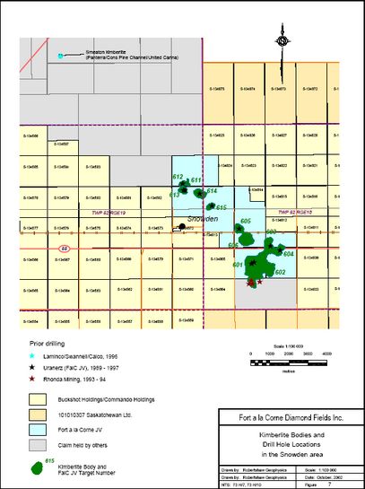
5.2.4 Drilling Results from the Snowden Kimberlites
A cluster of eleven kimberlite bodies occurs near the village of Snowden, adjacent to claims
held by Buckshot Holdings/Commando Holdings and 101010307 Saskatchewan Ltd. The Fort à<br>la Corne JV completed 10 drillholes on the Snowden kimberlite bodies between 1989 and 1997.
14
The hole locations are indicated by black star symbols in Figure 7.
Table 6: Snowden area drill holes (Fort à la Corne JV) in SIR Open Files
SIR Open
File
Company Drillhole Year Overburden Top of
Kimberlite
(m)
Kimberlite
thickness
(m)
EOH
(m)
73H-0001 Uranerz 613-1 1989 79.9 79.9 41.1* 121
73H-0001 Uranerz 601-1 1989 82.3 82.3 45.7* 128
73H07-0016 Uranerz 604-1 1993 82.3 82.3 97.4 200
73H07-0020 Uranerz 603-1 1994 89 89 207 300
73H07-0020 Uranerz 614-1 1994 141 141 175* 316
73H-0008 Uranerz 601-2 1996 84.5 84.5 128.5 216
73H-0008 Uranerz 613-2 1996 79 79 41.0* 120A
73H-0008 Uranerz 615-1 1996 120.5 166.5 181.5* 348.0
73H07-0026 Uranerz 605-1 1997 109.1 109.1 125.0* 234.1
73H07-0026 Uranerz 612-1 1997 75.0 75.0 57.3 164.6
Note:
* Hole ended in kimberlite
A Hole abandoned
Drillholes 601-1 and 613-1 (1989) penetrated less than 50 m of kimberlite and were terminated
in kimberlite. Seven microdiamonds were recovered from 88.5 kg of kimberlite obtained in hole
601-1. The 58.5 kg of kimberlite from hole 613-1 contained no microdiamonds.
Drillhole 604-1 (1993, HQ core) intersected 97.4 m of mainly fine to very fine grained kimberlite
with intercalated sediments in the lower 20 m of the intercept. No microdiamonds (or
macrodiamonds) were recovered from the 199 kg of kimberlite obtained.
1994 drillhole 603-1 investigated the very strongly magnetic anomaly (1400 nT peak amplitude)
which was predicted to be caused by a deep-going kimberlite body, possibly a diatreme. A 12”<br>diameter reverse circulation hole was drilled to 300 m depth, intersecting 207 m of kimberlite.
The kimberlite is described as very, very fine grained. From 37.742 tonnes of kimberlite
theoretically excavated, 28.82 tons of chips were retained. One macrodiamonds (0.27 ct) and
one microdiamond were recovered from this hole. The effective grade was calculated to be
l.51 cpht, although the samples size is too low for a meaningful grade value.
Also in 1994, using the 12” diameter reverse circulation (RCA) method, drillhole 614-1 was
terminated in kimberlite at a depth of 316 m due to drilling problems. This hole had intersected
175 m of kimberlite from the apparent bedrock surface at 141 m depth. The kimberlite was
described as fine grained. The hole excavated a theoretical mass of 26.741 tonnes of
kimberlite, of which 18.39 tonnes of sample were retained. Seventeen microdiamonds were
recovered, and a grade estimate of 5.33 cpht was reported.
|
|
|
|
Post by Franko10 ™ on Nov 29, 2004 9:24:08 GMT -5
|
|
|
|
Post by Franko10 ™ on Nov 29, 2004 9:24:23 GMT -5
In 1996, a 5” diameter reverse circulation drill system was used for 3 holes. Drill hole 601-2 was
intended to test the encouraging microdiamond count obtained in the 1989 drillhole. This hole
intersected 128.5 m of kimberlite and provided 2.84 tonnes of retained sample. One
macrodiamond and 24 microdiamonds were recovered, and the grade was estimated at 0.2
cpht.
Drill hole 613-2 attempted to follow up the 1989 drilling at kimberlite 613. This hole was lost
after hitting an artesian aquifer at 120 m depth. Forty-one metres of kimberlite intersection, with
1.036 tonnes of retained sample (very, very fine grained olivine kimberlite) had been acquired at
that point. No microdiamonds were recovered and processing for macrodiamonds was not
attempted.
Also in 1996, 5” RCA drill hole 615-01intersected 181.5 m of kimberlite and was terminated in
kimberlite at 348.0 m depth, which was the rated depth capacity of the drill. From a theoretical
mass of 6.497 tonnes, 3.215 tonnes of kimberlite chips (>0.85 mm size) were retained.
Microdiamond analyses were completed on 8 composite samples weighing 68.55 kg, and 3
microdiamonds were recovered. No macrodiamond processing was performed.
1997 drilling consisted of 5” rotary holes at targets 605 and 612. Drillhole 605-1 intersected
125.0 m of kimberlite beneath 109.12 m of overburden. The kimberlite was described as
dominantly poorly-sorted, fine- to medium grained olivine kimberlite. From a theoretical
intersected mass of 3.855 tonnes, kimberlite chips with a total mass of 2.087 tonnes were
retained. Microdiamond recovery by caustic fusion was performed on 44 kg of material, and 9
stones were recovered. The calculated microdiamond density for the entire hole was 212.9
stones/tonne. Macrodiamond recovery was performed on 1.892 tonnes of kimberlite, and no
stones were recovered.
The 1997 drill hole 612-1 intersected 57.3 m of kimberlite at a depth of 75.0 m. The kimberlite
interval consisted of interbedded altered kimberlite and kimberlitic sediments. The total retained
kimberlite mass was 1.173 tonnes (representing 1.834 tonnes theoretical mass). 12.3 kg of
samples were submitted for microdiamond analysis, and 1.082 tonnes of kimberlite were
processed for macrodiamonds. No micro- or macro-diamonds were recovered.
I
ndicated overburden depths for the Snowden area seem to be highly variable. Several holes
indicate depths in the 75 m to 89 m range, which are the lowest values within the FalC area
other than for portions of the Star kimberlite body which is located in the fringe of the
Saskatchewan River valley. Possibly some thicker overburden values from the Snowden area
drilling may be due to overdrilling.
6 Geological Setting
A generalized geological section in the Fort à la Corne area consists of approximately 100 m of
glacial overburden, some 500 m to 600 m of unmetamorphosed Phanerozoic sediments, and
underlying Archean crystalline rocks. The kimberlites discovered so far (other than glacially
rafted blocks) are contained within the Phanerozoic sediments, and are typically at or a few
metres below the base of the overburden.
6.1 Basement Geology
The crystalline basement in the Fort à la Corne area is part of a belt of Archean and Early
Proterozoic rocks, up to 600 km wide, which can be traced from South Dakota, through eastern
|
|

 Owner
Owner