|
|
Post by Franko10 ™ on Nov 29, 2004 9:25:49 GMT -5
|
|
|
|
Post by Franko10 ™ on Nov 29, 2004 9:26:16 GMT -5
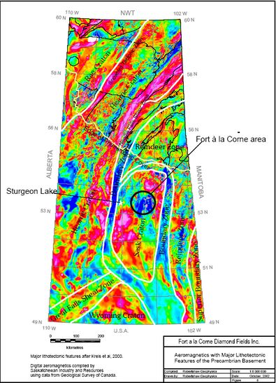
Saskatchewan to Hudson Bay and at least as far as central Greenland (Lewry and Collerson,
1990). This belt, the Trans-Hudson Orogen, is the expression of the Himalayan-scale collision
of the Superior plate and the Hearne-Rae-Slave platform which occurred between 1850 and
1800 Ma, and is a major component in the formation of the present day North American
continent. Archean and Early Proterozoic rocks of the Trans-Hudson Orogen are exposed in
the Shield area of northern Saskatchewan, some 150 km north of the Fort à la Corne area.
A major study of the architecture of the Trans-Hudson Orogen in Saskatchewan and Manitoba
was undertaken during the 1990’s as part of the Canada-wide LITHOPROBE program. Deep
crustal seismic profiles were acquired near the shield margin during 1991 and 1993,
accompanied by a wide range of geological, geophysical, geochemical and geochronological
studies. A similar program (COCORP) had been active in U.S.A. during the 1980’s, and
included a deep seismic transect of the Trans-Hudson Orogen in Montana and North Dakota,
approximately 700 km further south. A significant outcome of the LITHOPROBE and COCORP
programs has been the recognition of a third microcontinent-scale crustal component lying
between the Superior craton in the east, and the Hearne (in Canada) and Wyoming (in the US)
cratons in the west. In both cases, a 200 to 300 km-wide buried block is overridden in the east
by Superior crustal rocks, and is overridden in the west by Hearne or Wyoming crustal rocks
(Lucas et al, 1994, Baird et al., 1995), with intervening belts of highly deformed
Paleoproterozoic volcanics and sediments, and intrusives (the Superior boundary zone
including Thompson Belt in the east, the La Ronge Belt and Wathaman Batholith in the west).
The Paleoproterozoic rocks, largely representing island arc volcanics and associated
sediments, oceanic crust and continental margin sediments which avoided subduction, and
younger intrusives, collectively comprise the Reindeer Zone (Figure 8).
I
n Canada, the newly recognized Archean block has been named the Sask craton. Early
Proterozoic volcanic and sedimentary gneisses of the Glennie, Flin Flon and Kisseynew
Domains, which are components of the Reindeer Zone, overlie the northern portion of the Sask
craton where the Trans-Hudson Orogen swings from a north-south trend in east-central
Saskatchewan, to an east-west trend through northern Manitoba. Three small windows of
reworked Archean rocks, including the 2450 Ma Sahli Granite in the Pelican Lake area west of
Flin Flon (Heaman et al, 1995) seem to represent an exposed tip of the Sask craton. In North
Dakota, the buried Archean block imaged by COCORP is approximately 200 km in width and is
known as the Dakota block. This basement unit is entirely unexposed and lies largely beneath
the deeper portions of the Williston Basin. Although they appear similar, the relationship
between the Sask craton and the Dakota block is not clear.
From regional aeromagnetic and gravity coverage, the sub-Phanerozoic footprint of the Archean
Sask craton is thought to be approximately 450 km north-south x almost 200 km east-west, as
shown in Figure 8. This interpretation, taken from Kreis et al., 2000, implies that the Dakota
block is presently not attached to the Sask craton, although they may both be fragments of the
same parent block.
6.2 Crustal Structures
Like other Archean terrains, the Sask craton is most probably an assemblage of subcomponents
which have become welded together during prior episodes of continental accretion.
The magnetic expression of the Sask craton (Figure 8) shows that at least 3 subdivisions can be
made (northwest, central and southeast segments) based on differing magnetic characteristics.
Regional gravity coverage shows similar zoning.
|
|
|
|
Post by Franko10 ™ on Nov 29, 2004 9:28:05 GMT -5
|
|
|
|
Post by Franko10 ™ on Nov 29, 2004 9:34:27 GMT -5
North-south and northwest-southeast oriented trends are apparent in the regional gravity and
aeromagnetic coverage over the Sask craton. While the most prominent aeromagnetic features
are often the youngest, and not necessarily the most crustal-penetrative features, correlations
between magnetic and gravity lineations are probably more significant. On this basis, the set of
north-south lineations extending through the Fort à la Corne area (shown in Figure 9) possibly
represent deep-going structures. The northwest trends might be younger and could be
relatively shallow-soled features. These features might provide a system of oriented conduits
through the Sask craton crust which have affected the emplacement of the kimberlite bodies.
6.3 Phanerozoic Geology
Subcropping Phanerozoic rocks within the Fort à la Corne area are mostly shales and
mudstones of the mid- to late-Cretaceous Colorado Group. In regional mapping by
Saskatchewan Geological Survey, the majority of the Fort à la Corne area is underlain by Lower
Colorado Subgroup sediments which dip gently towards the southwest. Upper Colorado
Subgroup units are found mainly south of the Saskatchewan River. A 20 km-wide, northeast to
east-west trending tongue of Upper Colorado units extends through Prince Albert as far as
Smeaton, and this may represent a basement graben structure. The region west of Candle
Lake is thought to be underlain by older (early Cretaceous) Mannville Group sediments, which
are largely poorly consolidated sandstones. All the Fort à la Corne area kimberlite bodies
discovered so far occur within Upper and Lower Colorado Group shales and the underlying
Mannville Group sediments.
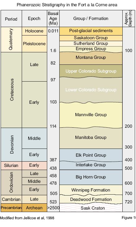
The basal 440 metres of the Phanerozoic column consist of Cambro-Ordovician to Devonian
sandstones and carbonates. Ordovician Red River carbonate units form prominent outcrops
along the Hanson Lake road to the east of Deschambault Lake, which is at the shield margin
some 150 km to the northeast. A generalized stratigraphic column is shown in Figure 10.
Throughout much of Phanerozoic time, most of Saskatchewan was subjected to multiple cycles
of marine deposition, interspersed with intervals of erosion. Multiple and frequent marine
transgressions and regressions over a wide area of western North America have been
documented, as shown in Figure 11.
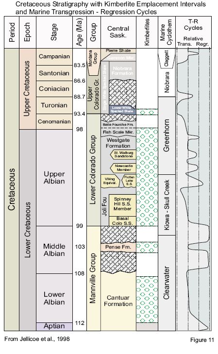
6.4 Kimberlite Emplacement and Architecture
Many, possibly hundreds, of individual kimberlite eruptions are thought to have occurred during
a 20 million year time span in the Fort à la Corne area. High energy volcanoes, driven by the
explosive degassing of a volatile-rich magma, produced shallow craters in the soft Cretaceous
sediments. The craters became filled by pyroclastic lapilli and olivine crystal tuffs deposited in
both sub-aerial and sub-aqueous environments. Individual eruptions probably culminated in the
formation of tephra cones or rings. If positive relief cones were formed, they were probably
rapidly eroded in the shallow marine environment. Feeders for the kimberlite bodies may not
have been preserved in the soft Cretaceous sediments (Scott-Smith, et al., 1994).
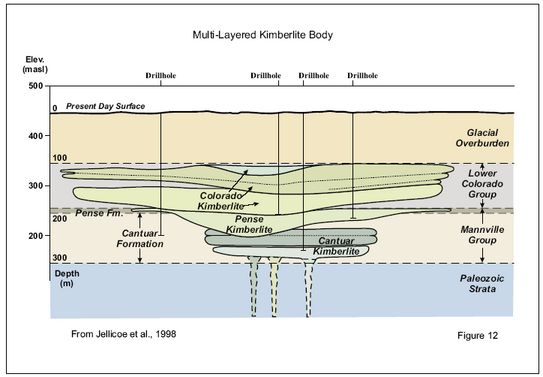
The kimberlite bodies currently found in the Fort à la Corne area are thought to be constructed
from the eroded remnants of many individual eruptions. Evidence of periods of quiescence
between eruptions is seen in erosional horizons within kimberlite bodies. Many of the bodies
seem to be composed of stacked, distinct horizontal layers of pyroclastic crater-facies kimberlite
which are thought to represent individual eruptive cycles. Figure 12 shows the conceptual
stratigraphical arrangement of a typical Fort à la Corne kimberlite body in cartoon form. The
larger kimberlite bodies appear to be coalesced from a number of adjacent eruption centers
(Jellicoe et al., 1998).
|
|
|
|
Post by Franko10 ™ on Nov 29, 2004 9:50:20 GMT -5
|
|
|
|
Post by Franko10 ™ on Nov 29, 2004 9:51:52 GMT -5
|
|
|
|
Post by Franko10 ™ on Nov 29, 2004 9:52:10 GMT -5
|
|
|
|
Post by Franko10 ™ on Nov 29, 2004 9:53:27 GMT -5
7 Deposit Types
7.1 Economic Considerations
The diamond contents of Fort à la Corne kimberlites are recognized to be low grade – by as
much as an order of magnitude in comparison to some producing mines elsewhere. Mitigating
factors are their extreme large size and accessibility, and the high proportion of gem quality
stones.
The evaluation of these large and low grade deposits requires disproportionately more sampling
than the small and high grade deposits which are being mined in NWT (e.g. the Ekati and Diavik
pipes). Of particular importance is the occurrence of high value, multi-carat stones. Stones
over 1 carat in size have been elusive; 3 have been recovered so far, all from the FalC JV
kimberlite 141. The largest diamond, 3.35 carats, was recovered in the 2001 sampling program.
De Beers have applied a modelling approach to estimate stone size distributions, and diamond
values, using a proprietary database of kimberlite sampling data. Their degree of confidence in
the modeled values increases as larger parcels of diamonds are recovered.
The key exploration issue since 1989 has been to find the most cost-effective way to evaluate
the diamond contents of these bodies. Due to the depth of glacial cover, generally about 100 m,
traditional methods of high volume sampling have been unattainable. A number of different
drilling methods have been employed to obtain appropriate sample volumes, depending on the
stage of investigation at each particular kimberlite body. Since garnets and microdiamonds are
far more abundant in kimberlite than macrodiamonds, indicator mineral chemistry and
microdiamond recoveries and size populations have been used to predict prospectivity for
commercial sized stones, thereby providing a tentative evaluation of the kimberlite bodies from
smaller samples.
Generally, core holes (NQ) and rotary drill holes (up to 6 inch diameter) have been used in initial
tests of kimberlite bodies to obtain relatively small samples for indicator mineral and
microdiamond testing. Kimberlites deemed to be more prospective have been sampled by minibulk
testing for macrodiamonds using larger diameter holes.
Starting in 1989, the FalC JV adopted the definition of a macrodiamond to be a stone having at
least 1 dimension greater than 1 mm in length. Shore Gold and the Candle Lake JV adopted
the standard of greater than 0.5 mm size. More recently, for the 2000 and 2001 sampling
programs, the FalC JV have further classified stones larger than 1.5 mm (square mesh) as
commercially recoverable.
7.1.1 Results from the FalC JV
Early drilling by the FalC JV, which utilized relatively small sample sizes, returned generally low
diamond grades, typically 0 to 10 carats per hundred tonnes (cpht), which appeared to be
unattractive if the kimberlites were in the form of diatremes as is normally the case elsewhere.
With 100 m of overburden cover, it was generally expected that diamond grades would need to
be quite high (i.e. 50 cpht or more) to justify mining. Starting in the mid 1990’s, the unusually
large size and horizontally stratified form of the kimberlites became clearer, and the consistently
high proportion of gem quality stones led to an appreciation that high volume mining might be
viable. Also, it became clear that early sampling results may have been underestimated due to
diamond recovery problems.
|
|
|
|
Post by Franko10 ™ on Nov 29, 2004 9:53:39 GMT -5
19
Up to and including the 1997 program, as reported in Jellicoe et al., (1998), the Fort à la Corne
joint venture had completed 174 drill holes (total of 39 195 m), almost half of which were reverse
circulation air blast (RCA) with diameters ranging from 152 to 305 mm (mini-bulk testing
programs). A 300 mm diameter drill hole cuts a theoretical mass of 17.7 tonnes from a 100
metre thick intersection of kimberlite. Typically, 35 to 50% of the theoretical mass might be lost
in fines (mud) during the drilling and recovery process. Larger diameter holes generally provide
lower costs per tonne of recovered kimberlite. Underreaming, which expanded borehole
diameters to as much as 457 mm through the kimberlite section, was tested by the FalC JV on
15 holes and has been discontinued due to poor kimberlite recovery. From the 174 drillholes
which had been completed by 1998, 19 235 metres of kimberlite intersections had provided
1005 tonnes of core and screened kimberlite chip samples representative of 1645 tonnes of
theoretical, in-situ kimberlite.
To 1998, 34 of the 69 bodies tested by the FalC JV had produced macrodiamonds, with a total
of 35.5 carats recovered. Almost 70% of the macrodiamonds were considered to be of gem
quality (Jellicoe et al., 1998). Up to and including the 2000 sampling program, an estimated
2180 (theoretical) tonnes of kimberlite had been sampled, with 79.1 carats of macrodiamonds
recovered (Kensington Resources new releases of November 1, 2000, and March 13, 2001).
From the 2000 program, for the first time, 2 diamonds over 1 carat in size (1.535 and 1.085
carats) were recovered from kimberlite 141.
I
n 2001, the FalC JV implemented an accelerated sampling program with a budget of $4.79
million, focused primarilly on kimberlite body 141. Sixteen 16 NQ core holes and ten 24 inch
diameter reverse flood holes was completed. Nine of the 24 inch holes were targeted at the
central portion of body 141, and the tenth hole was used to sample nearby body 150. Of the
889.8 tonnes theoretical mass of kimberlite sampled in 2001, 494 tonnes of wet chips larger
than 1.5 mm were retained for processing (Kensington news release of October 24, 2001).
Diamond recoveries from the 2001 program were announced in a June 13, 2002, news release
by Kensington Resources. The recovery of 3 additional macrodiamonds (total weight 3.755
carats) including one of 3.35 carats was reported in a July 23, 2002 news release. In all, a total
of 466 macrodiamonds, with a combined weight of 45.6 carats were recovered from the ten 24”<br>diameter holes. Eight stones were reported to be larger than 0.5 carat. From the 2001
program, 42.47 carats were obtained from kimberlite 141, and the average recovered grade for
this body (from the estimated 768 tonnes of kimberlite excavated in 2001) was 5.53 cpht. The
recoveries from kimberlite body 150 were lower, with an overall recovered grade of 2.6 cpht.
Estimates of value per tonne of kimberlite are highly dependent on the number and value of
larger gem quality stones. At this point, these values depend heavily on modelling of stone size
distributions and projected diamond values, rather than actual recovered stones. In a news
release of April 25, 2001, Kensington Resources announced that De Beers modelling results
indicated a projected grade of 18 cpht (with 1.5 mm recovery cut-off) for the 141 body, and the
projected diamond values were in the range US$90 to US$179 per carat. These predictions
were based on a study of microdiamonds and the 21.06 carats of macrodiamonds recovered at
that time. Body 141 is thought to contain 395 million tonnes of kimberlite based on geophysical
modelling. Since 2001, the FalC JV have revised the outline of body 141 to included the
adjacent, larger 140 kimberlite body. The mass of the combined bodies is thought to be
approximately 1 billion tonnes. Most recently (news release of October 15, 2002), Kensington
have announced that additional geophysical targets have been located nearby which may
represent further extensions of these bodies.
20
The accelerated sampling program of 2001 was intended to provide higher confidence in the
projected grade and per carat values for kimberlite 141/140 (Kensington Resources news
release of May 16, 2001). Updated grade and diamond value forecasts, incorporating the 2001
results, have not yet been released.
Body 140/141 is one of 6 large (+20 hectacres in size) kimberlite bodies (all located in the
southern portion of the kimberlite field, within the Fort à la Corne Forest) which are currently
favoured by the FalC JV as having the greatest economic potential. Three of the favoured
kimberlite bodies (141, 122 and 150) are identified in Figure 3.
The Falc JV program for 2002 was announced in a Kensington Resources news release dated
August 9, 2002. The program comprises core drilling and large diameter drill sampling of the
141/140 kimberlite with a budget of $5.2 million. The core drilling component, consisting of 25
NQ drill holes, has been completed (news release of October 15, 2002). The NQ holes were
distributed so as to improve the geological mapping of the larger body. Notable results are over
200 m thicknesses of kimberlite intersected in 2 holes, one of which (140-21) was terminated in
kimberlite at 369 m depth, and may represent a root zone of the kimberlite.
The 2002 large diameter drilling program, which is currently under way, was initially to consist of
ten 24 inch diameter holes. In the October 15 news release, Kensington Resources indicated
that the program had been changed to 3 holes of 36 inch diameter and 5 holes of 24 inch
diameter. Diamond recovery results from the 2002 program are not expected until early 2003.
Since 1989, the FalC JV have recovered a total of 124.7 carats of macrodiamonds (although the
lower size cut-off has changed during that period), from 3070 tonnes of kimberlite.
7.1.2 Results from the Shore Gold Star Kimberlite
The Star Kimberlite is located adjacent to the north shore of the Saskatchewan River and forms
the southeastern end of the Fort à la Corne kimberlite trend. The kimberlite body has been
mapped by geophysics and confirmed by drilling to extend over an irregular area of
approximately 4 km2, and has an estimated mass of 400 to 500 million tonnes. Drillhole Star 20
(reported in a Shore Gold news release of January 19, 2000) intersected 539 m of continuous
kimberlite, extending to a depth of 627 m. This is the deepest kimberlite encountered so far in
the Fort à la Corne area, and must represent a feeder zone, possibly a diatreme.
I
n a news release dated October 10,2001, Shore Gold summarized the results obtained to that
date from the Star Kimberlite. A total of 30 cores drillholes had been completed on the property,
with 26 of these holes testing the Star kimberlite. These included 1 PQ and 20 NQ size core
holes which have been completed during 2000 and 2001. In all, 4,623 kg of kimberlite had been
analysed, mostly by caustic dissolution, resulting in the recovery of a total weight of 1.477 carats
of diamonds (a global grade of approximately 32 cpht, including microdiamonds). In Shore’s
results, a macrodiamond is defined as having one dimension equal to or greater than 0.5 mm, in
contrast with the FalC JV practice of l.0 mm minimum size, and the more recent ‘commercial’<br>FalC JV criterion of l.5 mm size. Shore indicated that stones over l.0 mm in size accounted for
approximately 60% of the 1.477 carats recovered. The largest diamond reported to that date
weighed 0.05 carat. Despite the lack of larger stones, the grades reported by Shore were
notably higher than those of the FalC JV. Drillholes Star 020 and Star 023 of the 200/2001
program had reported grades of 61.0 cpht and 64.1 cpht, respectively, though from relatively
small sample sizes (626 kg of kimberlite for holes Star 202).
|
|
|
|
Post by Franko10 ™ on Nov 29, 2004 9:54:24 GMT -5
A 24” diameter drillhole (Star 031RC) was completed during October, 2001 (Shore news release
of November 5, 2001). Approximately 90 tonnes of kimberlite chips greater than 1.2 mm size
were recovered from a kimberlite intersection of approximately 192 m thickness. The hole
terminated in kimberlite at 296.5 m depth. Half the dense media separator concentrate from this
material was sent to Lakefield Research in Ontario, while the other half was processed at De
Beers facilities in Johannesburg.
The diamond recovery results from hole Star 031RC (reported in a Shore news release of May
21, 2002) consisted of 184 macrodiamonds (>1.1 mm square mesh size) weighing 8.52 carats
in total. Using an estimated theoretical excavated mass of 130 tonnes, the recovered grade is
6.7 cpht. The two largest recovered stones were 0.64 and 0.40 carats in weight, and both
appeared to be broken.
Shore have announced their intention to extract a large tonnage underground bulk sample,
possibly as large as 25 000 tonnes, to further evaluate the Star kimberlite body. This would
entail an exploration shaft and on-site processing facilities. Shore have indicated this work may
begin during 2002.
7.1.3 Results from the Candle Lake JV
In 1997, core samples from four 1996 NQ drillholes on the small C28 kimberlite body were
submitted for caustic fusion analysis by Kennecott Canada. The results were reported in 1997
(SIR Open File 73H10-0004). From 1.93 tonnes of kimberlite, a total of 191 diamonds were
recovered, of which 33 had one dimension grater than 0.5 mm. The total carat weight was not
provided, but the overall grade was stated to be less than 10 cpht.
A mini-bulk sample program (two 27 cm drill holes) was carried out by Kennecott Canada on the
C29/C30 body in 1998, and is reported in SIR Open File 73H15-0005. From a theoretical
sample size of 17.55 tonnes, 7.59 tonnes (dry sample weight) was recovered. Macrodiamond
recovery was performed on approximately half of the recovered kimberlite using dense media
separation. A total of 0.28 carats of diamonds greater than 1.0 mm in size were recovered,
indicating an overall grade of 3.7 carats per hundred tonnes. The two largest macrodiamonds
recovered each weighed 0.08 carats.
During 2002, Great Western Minerals Group completed 3 NQ core holes. The first hole
investigated a new geophysical (resistivity) target, and this proved not to be caused by
kimberlite. The remaining holes were drilled on the C29/C30 kimberlite body. 2002 drill hole
WSL-10 intersected 107 m thickness of kimberlite – the greatest thickness encountered so far at
this target. In a September 13, 2002, news release by Great Western Minerals Group, the
results of diamond recovery work on 25 kimberlite samples was presented. From a total of 170
kg of kimberlite, analysed by caustic dissolution, 126 diamonds were recovered. Five diamonds
were reported to be macrodiamonds (1 dimension greater than 0.5 mm). The total carat weight
was not reported.
8 Other Relevant Data and Information
8.1 Magnetics
The kimberlite bodies in the Fort à la Corne area lie beneath 75 to 150 m of cover and have no
surface expression. All have been discovered by geophysics (aeromagnetics) and therefore all
known kimberlites are magnetic to some degree. The magnetite content of the kimberlites is
22
thought to range from 0.1% to 4%, in contrast to the non-magnetic Phanerozoic sediments
which host the kimberlites.
The kimberlite’s magnetite content is largely provided by alteration (serpentinization) of olivine,
which is the main mineral constituent of fresh kimberlite. Magnetite is a bi-product of this
process and tends to form a fine grained ground mass within the kimberlite rock. Though rare,
some very large crystals of magnetite (up to 1 cm size) have been noted in FalC JV drilling, and
these are most likely primary constituents of the kimberlite magma. Magnetite weathers easily,
forming non-magnetic higher oxides if exposed to oxidizing fluids (groundwater). That the Fort à<br>la Corne kimberlites remain strongly magnetic after 100 Ma exposure to groundwater is
probably due to two factors; the Colorado shales have low fluid permeability, and the kimberlite
bodies seem to form a sealing carbonate-rich rind which probably reduces penetration by
groundwater.
Magnetic responses from crystalline basement, which is greater than 600 m below the ground
surface, may be differentiated by their longer wavelengths from the sharper signatures of the
kimberlite bodies.
Most of the Fort à la Corne kimberlite bodies produce ground mag anomalies in the range 200
nT to 600 nT. The highest anomaly is 1400 nT (Lehnert-Thiel et al., 1992). Some weakly
magnetic kimberlites may be difficult to differentiate from other sources, such as diagenetic
magnetite in overburden or bedrock, or anomalies caused by topography where the edges of
weakly magnetic till sheets are exposed. Groups of magnetic boulders in the overburden can
also provide similar signatures. Weak magnetic signatures are often relatively more noisy (ie.
poor signal/noise ratio) due to a fairly ubiquitous 2 – 5 nT noise component in ground mag
surveys caused by near surface boulders in till. Magnetic anomalies less than 40 nT peak
amplitude are suspect for this reason, although some weak anomalies are caused by genuine
kimberlites, eg. the Smeaton kimberlite of Golden News et al., and Rhonda’s Foxford kimberlite.
An interesting aspect of modelling the magnetic signatures of the Fort à la Corne kimberlite
bodies is that the lensoid shapes of the kimberlites produce anomaly shapes which are in many
respects identical to those from deep-going cylindrical models which would represent pipes or
diatreme-type kimberlite bodies. During the early years of the Fort à la Corne JV project, each
kimberlite body was assumed to be a diatreme, as commonly encountered in other parts of the
world. The distinctive flat-lying lensoid model was adopted only after conclusive evidence from
drilling (Jellicoe et al, 1998).
|
|
|
|
Post by Franko10 ™ on Nov 29, 2004 9:54:39 GMT -5
Also, Jellicoe et al. note that many of the Fort à la Corne kimberlite bodies appear to have a
weakly magnetic halo which commonly seems to be developed more extensively towards the
south or southwest of the main magnetic feature. This might represent a reworked peripheral
apron of kimberlite, or perhaps distally deposited material which might be down-current or
down-wind from a volcanic centre
8.2 Gravity
According to Jellicoe, et al., by 1998, the Fort à la Corne JV had obtained 219 km of gravity
profiles over 29 kimberlite targets. The effectiveness of gravity surveys depends on density
contrasts between kimberlite and the enclosing Phanerozoic sediments. This might be as high
as 0.2 gm/cc (ie. perhaps 2.6 gm/cc for the kimberlite vs 2.4 gm/cc for Lower Colorado shales).
The gravity signatures from the 29 Fort à la Corne JV kimberlite targets were described as
positive peaks ranging from 0.1 to over 1.0 milliGals in amplitude.
23
Two applications where gravity coverage might be advantageous are:
• Locating thick portions (possible root zones) of larger kimberlite bodies.
• Screening weakly magnetic targets which might have non-kimberlite causes, eg.
differentiating boulders or magnetite concentrations in till.
Gravity survey costs are at least 10x more than ground mag coverage of the same area. In
areas without a thick forest canopy, differential GPS measurements can provide horizontal and
vertical control with an accuracy of a few centimetres, which is adequate for the required survey
precision. Linecutting may not be necessary in thin bush. The Fort à la Corne area is mostly
flat, and much is agricultural land, which is ideal for gravity work.
8.3 Resistivity
Kimberlite bodies should tend to be more highly resistive than their enclosing Phanerozoic
sediments, which are largely Lower Colorado mudstones and shales, and so should produce
high resistivity anomalies with properly designed surveys.
The 100 m-thick overburden consists largely of sand near surface, becoming progressively clayrich
at depth. From resistivity test surveys at 4 sites, Jellicoe et al, (1998) report apparent
resistivity values for overburden averaging 10 to 20 ohm-metres in resistivity. The resistivity of
Colorado Group shales is estimated to be approximately 5 ohm-metres, and Mannville Group
sandstone units are thought to have resistivities in the 100 ohm-metre range. Kimberlite
resistivities can be highly variable, depending on the degree of alteration and porosity. From
test survey data over a low number of bodies it seems that these kimberlites fall in the range 20
to 100 ohm-metres.
Field tests by the Fort à la Corne JV in 1990 demonstrated that gradient array surveys, which
are relatively rapid and cheap, are more effective in detecting kimberlite bodies as positive
resistivity anomalies, probably due to more effective current penetration through the conductive
overburden. (SEM Open File 73H-0002).
Survey costs for gradient array resistivity work might be 2x comparable gravity survey costs.
8.4 Geotem Airborne Resistivity
Both the Fort à la Corne JV and the Candle Lake JV conducted Geotem airborne time domain
EM and aeromag surveys. The Fort à la Corne JV test was completed in 1996 and consisted of
coverage of a 12 km x 4 km block near Smeaton (300 m line spacing) which contained 10
known kimberlite bodies. All 10 known targets are identifiable in the EM data, though not as
clearly as in aeromagnetics due to a noisy background. Nine of the kimberlites produce high
resistivity anomalies, while one body, which is very strongly magnetic (calculated to be over 2%
magnetite content), is associated with a low resistivity anomaly (SEM Open File 73H-0008).
The Candle Lake JV flew a Geotem test survey in 1995 (SEM Open File 73-0011). This
comprised 7000 line km of coverage at 333 m line spacing. The survey outline was
approximately 55 km north-south x 40 km east-west, and included both known kimberlite bodies
(C28 and C29/30). The Geotem EM results were described as unclear over both targets, and
were possibly affected by the topography of the Cretaceous bedrock surface.
Although the Fort à la Corne kimberlite Geotem EM signatures were less clear than the
aeromagnetic anomalies, the combination of EM and aeromagnetics would be powerful when
dealing with much weaker magnetic features.
|
|
|
|
Post by Franko10 ™ on Nov 29, 2004 9:54:54 GMT -5
Geotem coverage might cost $70 to $80 per line km, depending on the survey size and cost of
mobilization.
8.5 TEM In-loop Soundings
The Fort à la Corne JV conducted a TEM sounding test survey in 1996 as a follow-up to the
GEOTEM survey (Jellicoe et al, 1998). The survey comprised three profiles with soundings at
100 m intervals over a 1 km-wide kimberlite body, and was successful in imaging the body as a
high resistivity zone within the lower resistivity Colorado shales. Higher resistivity values
representing the Mannville sandstones underlie each profile. A kimberlite body within the
Mannville sandstones might be imaged as a resistivity low.
The test survey used a 100 m x 100 m transmitter loop which needed to be moved for every
sounding. Survey costs for TEM sounding profiles are fairly high if the work is in forest as a
large crew is necessary and preparatory linecutting needs to be done. In farm land the survey
proceeds rapidly and costs should be comparable to resistivity surveys.
8.6 Seismic Reflection Surveys
In 1992 and ’93, GSC and University of Saskatchewan conducted high resolution seismic
surveys over a kimberlite body in farm land south of Smeaton. The survey succeeded in
imaging the domed top of this body (probably not a common feature among the Fort à la Corne
kimberlites), and identified horizontal horizons within the kimberlite which were suspected to be
erosional features. The base of the kimberlite body was not well imaged, and there is no
conclusive evidence of a root zone or feeder. The seismic coverage suggested that thin,
peripheral kimberlite might extend considerably beyond the boundaries of the body as mapped
by magnetics and gravity. The results were published in 1996 (Gendzwill and Matieshin, 1996)
and were further refined in a U of S M.Sc. thesis (Matieshin, 1998).
Seismic survey costs are high, but the effectiveness of this method is also relatively high.
Seismic exploration profiles might be considered in priority areas, such as along trend from
known kimberlite bodies.
GSC also performed a suite of multi-parameter borehole logs on the same kimberlite body
(Richardson, et al., 1995, Mwenifumbo, et al., 1996) which demonstrated and quantified physical
property contrasts of the in situ kimberlite, including seismic velocity, magnetic susceptibility,
density and resistivity.
9 Interpretation and Conclusions
Seventy four kimberlite bodies have been confirmed in the Fort à la Corne area since 1988,
making this one of the largest kimberlite fields in the world. The Cameco/De Beers/Kensington
Joint Venture currently hold 63 confirmed kimberlite bodies. Eight kimberlite bodies are held by
Shore Gold, one by Cons. Pine Channel/Shane Resources/United Carina and two are held by
Great Western Gold/War Eagle Mining in the Candle Lake area.
The characteristic strongly magnetic signatures of the kimberlites promoted their rapid discovery
through affordable, high resolution aeromagnetic coverage. Modelling indicates that some
kimberlites must contain 2 to 4 % magnetite by weight, in contrast to the enclosing 600 m-thick
Phanerozoic sediments which are non-magnetic, and that contrast makes these bodies
extremely favourable targets for aeromagnetic surveys. The magnetite is almost entirely an
alteration product of the primary olivine content of the kimberlites. The magnetite seems to be
25
preserved mainly because the Upper and Lower Colorado shale units, the most common host
rocks of the kimberlite bodies, are largely impervious to ground water. Further alteration in
porous stratigraphy would almost certainly destroy the magnetite and render the kimberlite nonmagnetic.
Silty and sandy intervals are noted within the Lower Colorado stratigraphy, as shown
in Figure 11. The Mannville Group which underlies the Lower Colorado sediments is almost
entirely porous, poorly consolidated sandstone.
Exploration methods other than magnetics have been demonstrated to be effective, raising the
possibility that additional kimberlite bodies which might be non-magnetic, can to discovered.
Almost all of the kimberlite bodies seem to have been emplaced during the interval 95 to 115
Ma, when this region was subjected to repeated cycles of marine trangression and regression
as part of the shallow Western Interior Seaway. Pyroclastic crater-facies kimberlites, with both
airfall and water-lain characteristics, have been reported by the Cameco/De Beers/Kensington
Joint Venture. It seems that many of the kimberlites consist of multi-layered bodies, where
successive eruptions, separated by intervals of erosion and sedimentation, have produced a
succession of flat (beveled), roughly concentric, lensoid kimberlite layers. Occasional
intervening Cretaceous sediments separate some kimberlite layers and can be correlated
between drillholes in some of the larger bodies (Jellicoe et al., 1998). Some larger bodies (in
excess of 1 km diameter) are probably coalesced, multi-vent clusters.
In 2000, the Fort à la Corne JV began sampling with 24 inch diameter holes, producing almost
100 tonnes of kimberlite per hole. This has been accelerated and continued in 2001 and 2002,
also with the addition of 36 inch diameter holes in the 2002 program. The change in sampling
method addresses the major problem which has inhibited the evaluation of the Fort à la Corne
kimberlites since their discovery, namely the cost of acquiring adequate quantities of kimberlite
for analysis. Prior to the 2000 program, less than 60 tonnes of kimberlite had been recovered
from body 141. The cumulative amount after the 2002 program is expected to be over 2000
tonnes.
The 2002 evaluation program of the FalC JV, as announced in a Kensington Resources news
release of August 9, 2002, is directed entirely at the 141/140 kimberlite body. Included in the
$5.2 million budget are initial ore dressing studies and a ‘conceptual modeling exercise’ to
provide thresholds for preliminary mining feasibility studies.
Shore Gold’s sampling of the Star kimberlite has also accelerated. From 26 core holes which
had been completed by the summer of 2001, less than 5 tonnes of kimberlite had been
recovered. The single 24 inch diameter hole (Star 031RC) completed in the fall of 2001
increased the amount to almost 95 tonnes. Shore Gold are said to be prepairing to undertake a
25 000 tonne underground bulk sample as their next step in evaluating the Star kimberlite.
The accelerated pace of kimberlite evaluation at the 2 major projects demonstrates that the
impediment posed by 100 m-thick overburden can be overcome, given sufficient preliminary
encouragement, which news should be well received by other property holders.
10 Recommendations
Since the immediate Fort à la Corne area has received considerable exploration attention since
1988, particularly aeromagnetic and ground magnetic surveys, it may be assumed that any
further kimberlite discoveries in this area will be either very weak or unusual magnetic features
|
|
|
|
Post by Franko10 ™ on Nov 29, 2004 9:56:14 GMT -5
|
|
|
|
Post by Franko10 ™ on Nov 29, 2004 9:56:27 GMT -5
(eg. reversely magnetized anomalies), or essentially non-magnetic. A dual-track exploration
program is recommended. Firstly, at low cost, targets might be developed from the existing
aeromagnetic coverage. Secondly, an effective method of detecting non-magnetic kimberlite
bodies should be applied.
The first, low cost approach would consist of the following:
The existing high quality, public domain aeromagnetic coverage of the 5 properties,
where available, should be thoroughly checked for weak and subtle anomalies.
Anomaly sites should be visually inspected for possible cultural magnetic sources.
Ground mag test profiles should be completed to confirm prospective targets.
Since the magnetic expressions will be weak and/or of unusual form, screening of
priority targets by the use of gravity, resistivity or TEM soundings, where appropriate,
would be recommended. Targets surviving the screening process would be
recommended for drill testing.
In the second approach, an airborne survey would be conducted to search for essentially nonmagnetic
kimberlite bodies. The survey would be designed to map the ground resistivity at
bedrock depth:
Currently, the Geotem EM system operated by Fugro Airborne Surveys (formerly
Geoterrex) seems to provide the most appropriate, commercially available system. This
is a fixed wing, Time Domain EM system, complemented by aeromagnetics, which has
already been tested in this area (Candle Lake area in 1995 and in the Smeaton area of
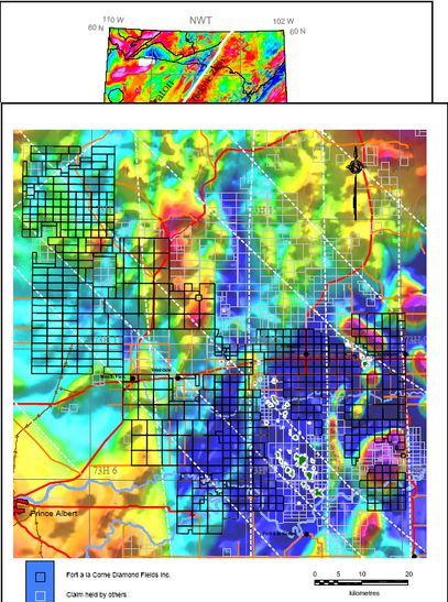
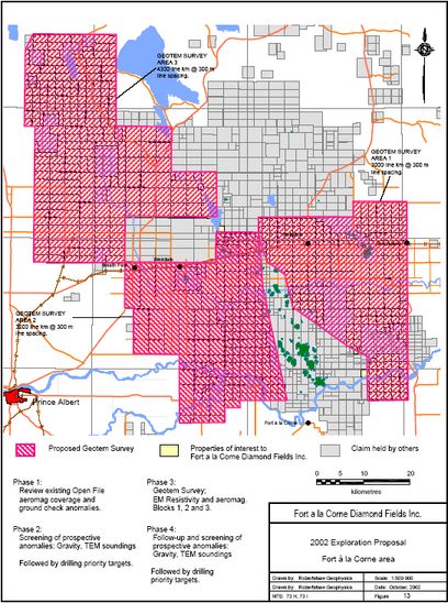
the Fort à la Corne JV property in 1996). As shown in Figure 13, coverage of the 5
properties with 300 m line spacing could be achieved in 3 survey blocks as follows:
Block 1 (Fort à la Corne East) 3000 line km
Block 2 (Fort à la Corne West) 3200 line km
Block 3 (Candle Lake West) 4300 line km.
Approximately 10 500 line km of airborne survey would be required for complete coverage of
the properties with 300 m line spacing.
Targets derived from the airborne resistivity survey should be screened by gravity, ground
resistivity or TEM soundings, as appropriate, before drilling, if warranted.
Respectfully submitted,
P. Robertshaw, P.Geo.
27
11 References
Bank, C.-G., Ellis, R.M., Bostock, M.G., Hajnal, Z. and VanDecar, J.C., 1997; Lithospheric Mantle
Structure Beneath the Trans-Hudson Orogen from Teleseismic Travel-Time Inversion; in LITHOPROBE
Trans-Hudson Orogen Transect, Report No. 62, University of Saskatchewan, p. 6-9.
Chiarenzelli, J.R., Aspler, L.B. and Villeneuve, M., 1996; Characterization, Origin, and Paleoproterozoic
History of the Saskatchewan Craton and Possible Implications for Trans-Hudson Orogen; in
LITHOPROBE Trans-Hudson Orogen Transect, Report of Sixth Transect Meeting, Report No. 55,
University of Saskatchewan, p. 26-38.
Collerson, K.D., Lewry, J.F., Van Schmus, R.W. and Bickford, M.E., 1989; Sm-Nd constraints on the age
of the basement in central and southern Saskatchewan: Implications for diamond exploration; in
Summary of Investigations 1989, Saskatchewan Geological Survey, Miscellaneous Report 89-4, p. 168-
171.
Dufresne, M.B., Olson, R.A., Schmitt, D.R., McKinstry, B., Eccles, D.R., Fenton, M.M., Pawlowicz, J.G.,
Edwards, W.A.D. and Richardson R.J.H., 1994a; The diamond potential of Alberta: A regional synthesis
of the structural and stratigraphic setting, and other preliminary indications of diamond potential, Alberta
Research Council Open File Report, 1994-10, 349 pp.
Gendzwill, D.J., and Matieshin, S.D., 1996; Seismic Reflection Survey of a kimberlite intrusion in the Fort
à la Corne District, Saskatchewan; in Searching for Diamonds in Canada, Geological Survey of Canada
Open File 3228, p. 251-254.
Jellicoe, B.C., Robertshaw, P., Williamson, P. and Murphy, J., 1998; Summary of Exploration Activities
and Results for the Fort à la Corne Diamond Project, Saskatchewan; in Summary of Investigations 1998,
Saskatchewan Geological Survey, Sask. Energy Mines, Misc. Rep. 98-4, p. 144-157.
Kauffman, E.G., and Caldwell, W.G.E., 1993; The Western Interior Basin in space and time; in Caldwell,
W.G.E. and Kauffman, E.G., Evolution of the Western Interior Basin: Geological Association of Canada,
Special Paper 39, p. 1-30.
Kries, L.K., Ashton, K.E. and Maxeiner, R.O., 2000; Geology of the Precambrian basement and
Phanerozoic strata in Saskatchewan; Sheet 1 of 8, Lower Paleozoic Map Series, Saskatchewan Energy
and Mines Open File Report 2000-2.
Kjarsgaard, B.A., 1995; Research on Kimberlites and Applications of Diamond Exploration Techniques in
Saskatchewan; in Investigations completed by the Saskatchewan Geological Survey and the Geological
Survey of Canada under the Geoscience Program of the Canada-Saskatchewan Partnership Agreement
on Mineral Development (1990-1995), (ed.) D.G. Richardson, Geological Survey of Canada Open File
3119/Saskatchewan Geological Survey Open File 95-3, p. 213-226.
Leckie, D.A., Kjarsgaard, B.A., Bloch, J., McIntyre, D., McNeil, D., Stasiuk, L. and Heaman, L., 1997;
Emplacement and reworking of Cretaceous, diamond-bearing, crater facies kimberlite of central
Saskatchewan, Canada; GSA Bulletin, vol. 109, no.8, p.1000-1020.
Lehnert-Thiel, K., Loewer, R., Orr, R.G. and Robertshaw, P., 1992; Diamond-bearing Kimberlites in
Saskatchewan, Canada: The Fort à la Corne Case History, Exploration and Mining Geology; Vol. 1, No.
4, pp. 391-403.
Lewry, J.F., Hajnal, Z., Green, A., Lucas, S.B., White, D., Stauffer, M.R., Ashton, K.E., Weber, W. and
Clowes, R., 1994; Structure of a Paleoproterozoic continent-continent collision zone: a LITHOPROBE
seismic reflection profile across the Trans-Hudson Orogen, Canada; Tectonophysics, vol. 232, p. 143-
|
|
|
|
Post by Franko10 ™ on Nov 29, 2004 9:56:51 GMT -5
Macnae, J.C., 1979; Kimberlites and exploration geophysics; Geophysics; vol. 44, No. 8, p. 1395-1416.
Matieshin, S.D., 1998; Seismic Investigation of a Fort à la Corne Kimberlite, Central Saskatchewan;
unpublished M.Sc. thesis, Univ. of Sask., 104p.
Mwenifumbo, C.J., Hunter, J.A.M., Killeen, P.G., 1996; Geophysical Characteristics of Canadian
kimberlites; in Searching for Diamonds in Canada, Geological Survey of Canada Open File 3228, p. 237-
240.
Richardson, K.A., Katsube, T.J., Mwenifumbo, T.J., Killeen, P.G., Hunter, J.A.M., Gendzwill, L, D.J. and
Matieshin, S.D., 1995; Geophysical studies of kimberlites in Saskatchewan; in Investigations Completed
by the Saskatchewan Geological Survey and the Geological Survey of Canada under the Geoscience
Program of the Canada-Saskatchewan Partnership Agreement on Mineral Development (1990-1995),
GSC open file 3119, Richardson, D.G., ed., pp 197-206.
Scott-Smith, B.H., Orr, R.G., Robertshaw, P. and Avery, R.W., 1994; Geology of the Fort à la Corne
kimberlites, Saskatchewan; in Proceedings of District 6 CIM Annual General Meeting. Diamonds, p.19-24.
|
|
|
|
Post by Franko10 ™ on Nov 29, 2004 9:57:22 GMT -5
APPENDIX 1
Listing of Fort à la Corne area claims held by:
Buckshot holdings Ltd. (50%) and Commando Holdings Ltd (50%)
101010307 Saskatchewan Ltd.
101012190 Saskatchewan Ltd.
101027101 Saskatchewan Ltd.
Morgain Minerals Inc.
1
CLAIM REGISTERED OWNER NTS MAP SHEET AREA
(ha)
EFFECTIVE
DATE
PROTECTED
UNTIL
S-134478 Buckshot/Commando 73-H-01 & -02 256 20010302 20030302
S-134479 Buckshot/Commando 73-H-02 256 20010302 20030302
S-134480 Buckshot/Commando 73-H-02 256 20010302 20030302
S-134481 Buckshot/Commando 73-H-02 256 20010302 20030302
S-134482 Buckshot/Commando 73-H-02 256 20010302 20030302
S-134483 Buckshot/Commando 73-H-02 256 20010302 20030302
S-134484 Buckshot/Commando 73-H-02 256 20010302 20030302
S-134485 Buckshot/Commando 73-H-02 256 20010302 20030302
S-134486 Buckshot/Commando 73-H-02 256 20010302 20030302
S-134487 Buckshot/Commando 73-H-01 & -02 256 20010302 20030302
S-134488 Buckshot/Commando 73-H-01 & -02 256 20010302 20030302
S-134489 Buckshot/Commando 73-H-02 256 20010302 20030302
S-134490 Buckshot/Commando 73-H-02 256 20010302 20030302
S-134491 Buckshot/Commando 73-H-02 256 20010302 20030302
S-134492 Buckshot/Commando 73-H-02 256 20010302 20030302
S-134493 Buckshot/Commando 73-H-02 256 20010302 20030302
S-134494 Buckshot/Commando 73-H-02 256 20010302 20030302
S-134495 Buckshot/Commando 73-H-02 256 20010302 20030302
S-134496 Buckshot/Commando 73-H-02 256 20010302 20030302
S-134497 Buckshot/Commando 73-H-02 256 20010302 20030302
S-134498 Buckshot/Commando 73-H-01 & -02 256 20010302 20030302
S-134499 Buckshot/Commando 73-H-01, -02, -07 & -08 256 20010302 20030302
S-134500 Buckshot/Commando 73-H-02 & -07 256 20010302 20030302
S-134501 Buckshot/Commando 73-H-02 & -07 256 20010302 20030302
S-134502 Buckshot/Commando 73-H-02 & -07 256 20010302 20030302
S-134503 Buckshot/Commando 73-H-02 & -07 256 20010302 20030302
S-134504 Buckshot/Commando 73-H-07 96 20010302 20030302
S-134505 Buckshot/Commando 73-H-07 256 20010302 20030302
S-134506 Buckshot/Commando 73-H-07 256 20010302 20030302
S-134507 Buckshot/Commando 73-H-07 256 20010302 20030302
S-134508 Buckshot/Commando 73-H-07 & -08 64 20010302 20030302
S-134509 Buckshot/Commando 73-H-07 & -08 256 20010302 20030302
S-134510 Buckshot/Commando 73-H-07 & -08 32 20010302 20030302
S-134511 Buckshot/Commando 73-H-07 256 20010302 20030302
S-134512 Buckshot/Commando 73-H-07 32 20010302 20030302
S-134513 Buckshot/Commando 73-H-07 96 20010302 20030302
S-134514 Buckshot/Commando 73-H-07 128 20010302 20030302
S-134515 Buckshot/Commando 73-H-07 & -08 192 20010302 20030302
S-134516 Buckshot/Commando 73-H-07 & -08 256 20010302 20030302
S-134517 Buckshot/Commando 73-H-07 256 20010302 20030302
S-134518 Buckshot/Commando 73-H-07 256 20010302 20030302
S-134519 Buckshot/Commando 73-H-07 256 20010302 20030302
S-134520 Buckshot/Commando 73-H-07 256 20010302 20030302
S-134521 Buckshot/Commando 73-H-07 256 20010302 20030302
S-134522 Buckshot/Commando 73-H-07 256 20010302 20030302
2
CLAIM REGISTERED OWNER NTS MAP SHEET AREA
(ha)
EFFECTIVE
DATE
PROTECTED
UNTIL
S-134523 Buckshot/Commando 73-H-07 256 20010302 20030302
S-134524 Buckshot/Commando 73-H-07 256 20010302 20030302
S-134525 Buckshot/Commando 73-H-07 256 20010302 20030302
S-134526 Buckshot/Commando 73-H-07 256 20010302 20030302
S-134527 Buckshot/Commando 73-H-07 & -08 256 20010302 20030302
S-134528 Buckshot/Commando 73-H-07 128 20010302 20030302
S-134529 Buckshot/Commando 73-H-07 32 20010302 20030302
S-134530 Buckshot/Commando 73-H-07 256 20010302 20030302
S-134531 Buckshot/Commando 73-H-07 256 20010302 20030302
S-134532 Buckshot/Commando 73-H-07 256 20010302 20030302
S-134533 Buckshot/Commando 73-H-07 256 20010302 20030302
S-134534 Buckshot/Commando 73-H-07 256 20010302 20030302
S-134535 Buckshot/Commando 73-H-07 256 20010302 20030302
S-134536 Buckshot/Commando 73-H-07 256 20010302 20030302
S-134537 Buckshot/Commando 73-H-07 256 20010302 20030302
S-134538 Buckshot/Commando 73-H-07 256 20010302 20030302
S-134539 Buckshot/Commando 73-H-07 256 20010302 20030302
S-134540 Buckshot/Commando 73-H-07 256 20010302 20030302
S-134541 Buckshot/Commando 73-H-07 256 20010302 20030302
S-134542 Buckshot/Commando 73-H-07 256 20010302 20030302
S-134543 Buckshot/Commando 73-H-07 256 20010302 20030302
S-134544 Buckshot/Commando 73-H-07 256 20010302 20030302
S-134545 Buckshot/Commando 73-H-07 256 20010302 20030302
S-134546 Buckshot/Commando 73-H-07 256 20010302 20030302
S-134547 Buckshot/Commando 73-H-07 256 20010302 20030302
S-134548 Buckshot/Commando 73-H-07 256 20010302 20030302
S-134549 Buckshot/Commando 73-H-07 256 20010302 20030302
S-134550 Buckshot/Commando 73-H-07 256 20010302 20030302
S-134551 Buckshot/Commando 73-H-07 256 20010302 20030302
S-134552 Buckshot/Commando 73-H-07 256 20010302 20030302
S-134553 Buckshot/Commando 73-H-07 256 20010302 20030302
S-134554 Buckshot/Commando 73-H-07 256 20010302 20030302
S-134555 Buckshot/Commando 73-H-07 256 20010302 20030302
S-134556 Buckshot/Commando 73-H-07 256 20010302 20030302
S-134557 Buckshot/Commando 73-H-07 256 20010302 20030302
S-134558 Buckshot/Commando 73-H-07 256 20010302 20030302
S-134559 Buckshot/Commando 73-H-07 256 20010302 20030302
S-134560 Buckshot/Commando 73-H-07 256 20010302 20030302
S-134561 Buckshot/Commando 73-H-07 256 20010302 20030302
S-134562 Buckshot/Commando 73-H-07 256 20010302 20030302
S-134563 Buckshot/Commando 73-H-07 256 20010302 20030302
S-134564 Buckshot/Commando 73-H-07 256 20010302 20030302
S-134565 Buckshot/Commando 73-H-07 256 20010302 20030302
S-134566 Buckshot/Commando 73-H-07 256 20010302 20030302
S-134567 Buckshot/Commando 73-H-07 256 20010302 20030302
S-134568 Buckshot/Commando 73-H-07 256 20010302 20030302
|
|
|
|
Post by Franko10 ™ on Nov 29, 2004 9:57:52 GMT -5
CLAIM REGISTERED OWNER NTS MAP SHEET AREA
(ha)
EFFECTIVE
DATE
PROTECTED
UNTIL
S-134569 Buckshot/Commando 73-H-07 256 20010302 20030302
S-134570 Buckshot/Commando 73-H-07 256 20010302 20030302
S-134571 Buckshot/Commando 73-H-07 256 20010302 20030302
S-134572 Buckshot/Commando 73-H-07 249 20010302 20030302
S-134573 Buckshot/Commando 73-H-07 256 20010302 20030302
S-134574 Buckshot/Commando 73-H-07 256 20010302 20030302
S-134575 Buckshot/Commando 73-H-07 256 20010302 20030302
S-134576 Buckshot/Commando 73-H-07 256 20010302 20030302
S-134577 Buckshot/Commando 73-H-07 246 20010302 20030302
S-134578 Buckshot/Commando 73-H-07 & -10 256 20010302 20030302
S-134579 Buckshot/Commando 73-H-07 & -10 256 20010302 20030302
S-134580 Buckshot/Commando 73-H-07 & -10 256 20010302 20030302
S-134581 Buckshot/Commando 73-H-07 & -10 256 20010302 20030302
S-134582 Buckshot/Commando 73-H-07 & -10 256 20010302 20030302
S-134583 Buckshot/Commando 73-H-10 256 20010302 20030302
S-134584 Buckshot/Commando 73-H-10 256 20010302 20030302
S-134585 Buckshot/Commando 73-H-10 256 20010302 20030302
S-134586 Buckshot/Commando 73-H-10 256 20010302 20030302
S-134587 Buckshot/Commando 73-H-10 128 20010302 20030302
S-134588 Buckshot/Commando 73-H-02 256 20010302 20030302
S-134589 Buckshot/Commando 73-H-02 256 20010302 20030302
S-134590 Buckshot/Commando 73-H-02 256 20010302 20030302
S-134591 Buckshot/Commando 73-H-02 256 20010302 20030302
S-134592 Buckshot/Commando 73-H-02 256 20010302 20030302
S-134593 Buckshot/Commando 73-H-02 256 20010302 20030302
S-134594 Buckshot/Commando 73-H-07 256 20010302 20030302
S-134595 Buckshot/Commando 73-H-07 256 20010302 20030302
S-134596 Buckshot/Commando 73-H-07 256 20010302 20030302
S-134597 Buckshot/Commando 73-H-07 256 20010302 20030302
S-134598 Buckshot/Commando 73-H-07 256 20010302 20030302
S-134599 Buckshot/Commando 73-H-07 256 20010302 20030302
S-134600 Buckshot/Commando 73-H-07 256 20010302 20030302
S-134601 Buckshot/Commando 73-H-07 256 20010302 20030302
S-134602 Buckshot/Commando 73-H-07 256 20010302 20030302
S-134603 Buckshot/Commando 73-H-07 256 20010302 20030302
S-134604 Buckshot/Commando 73-H-07 256 20010302 20030302
S-134605 Buckshot/Commando 73-H-07 256 20010302 20030302
S-134606 Buckshot/Commando 73-H-07 256 20010302 20030302
S-134607 Buckshot/Commando 73-H-07 256 20010302 20030302
S-134608 Buckshot/Commando 73-H-07 256 20010302 20030302
S-134609 Buckshot/Commando 73-H-07 256 20010302 20030302
S-134610 Buckshot/Commando 73-H-07 256 20010302 20030302
S-134611 Buckshot/Commando 73-H-07 256 20010302 20030302
S-134612 Buckshot/Commando 73-H-07 256 20010302 20030302
S-134613 Buckshot/Commando 73-H-07 256 20010302 20030302
S-134614 Buckshot/Commando 73-H-07 256 20010302 20030302
4
CLAIM REGISTERED OWNER NTS MAP SHEET AREA
(ha)
EFFECTIVE
DATE
PROTECTED
UNTIL
S-134615 Buckshot/Commando 73-H-07 256 20010302 20030302
S-134616 Buckshot/Commando 73-H-07 256 20010302 20030302
S-134617 Buckshot/Commando 73-H-07 256 20010302 20030302
S-134618 Buckshot/Commando 73-H-07 256 20010302 20030302
S-134619 Buckshot/Commando 73-H-07 256 20010302 20030302
S-134620 Buckshot/Commando 73-H-07 244 20010302 20030302
S-134621 Buckshot/Commando 73-H-07 256 20010302 20030302
S-134622 Buckshot/Commando 73-H-07 256 20010302 20030302
S-134623 Buckshot/Commando 73-H-07 256 20010302 20030302
S-134624 Buckshot/Commando 73-H-07 256 20010302 20030302
S-134625 Buckshot/Commando 73-H-07 256 20010302 20030302
S-134626 Buckshot/Commando 73-H-07 & -10 256 20010302 20030302
S-134627 Buckshot/Commando 73-H-07 & -10 256 20010302 20030302
S-134628 Buckshot/Commando 73-H-07 & -10 256 20010302 20030302
S-134629 Buckshot/Commando 73-H-07 & -10 256 20010302 20030302
S-134630 Buckshot/Commando 73-H-07 & -10 256 20010302 20030302
S-134631 Buckshot/Commando 73-H-07 & -10 256 20010302 20030302
S-134632 Buckshot/Commando 73-H-10 256 20010302 20030302
S-134633 Buckshot/Commando 73-H-10 256 20010302 20030302
S-134634 Buckshot/Commando 73-H-10 256 20010302 20030302
S-134635 Buckshot/Commando 73-H-10 256 20010302 20030302
S-134636 Buckshot/Commando 73-H-10 256 20010302 20030302
S-134637 Buckshot/Commando 73-H-10 256 20010302 20030302
S-134638 Buckshot/Commando 73-H-10 256 20010302 20030302
S-134639 Buckshot/Commando 73-H-10 256 20010302 20030302
S-134640 Buckshot/Commando 73-H-10 256 20010302 20030302
S-134641 Buckshot/Commando 73-H-10 256 20010302 20030302
S-134642 Buckshot/Commando 73-H-10 256 20010302 20030302
S-134643 Buckshot/Commando 73-H-10 256 20010302 20030302
S-134644 Buckshot/Commando 73-H-02 256 20010302 20030302
S-134645 Buckshot/Commando 73-H-02 256 20010302 20030302
S-134646 Buckshot/Commando 73-H-02 & -03 256 20010302 20030302
S-134647 Buckshot/Commando 73-H-03 256 20010302 20030302
S-134648 Buckshot/Commando 73-H-03 256 20010302 20030302
S-134649 Buckshot/Commando 73-H-03 256 20010302 20030302
S-134650 Buckshot/Commando 73-H-03 256 20010302 20030302
S-134651 Buckshot/Commando 73-H-03 256 20010302 20030302
S-134652 Buckshot/Commando 73-H-03 256 20010302 20030302
S-134653 Buckshot/Commando 73-H-02 & -03 256 20010302 20030302
S-134654 Buckshot/Commando 73-H-02 256 20010302 20030302
S-134655 Buckshot/Commando 73-H-02 256 20010302 20030302
S-134656 Buckshot/Commando 73-H-02 256 20010302 20030302
S-134657 Buckshot/Commando 73-H-02 256 20010302 20030302
S-134658 Buckshot/Commando 73-H-02 & -03 256 20010302 20030302
S-134659 Buckshot/Commando 73-H-03 256 20010302 20030302
S-134660 Buckshot/Commando 73-H-03 256 20010302 20030302
|
|
|
|
Post by Franko10 ™ on Nov 29, 2004 9:58:13 GMT -5
CLAIM REGISTERED OWNER NTS MAP SHEET AREA
(ha)
EFFECTIVE
DATE
PROTECTED
UNTIL
S-134661 Buckshot/Commando 73-H-03 256 20010302 20030302
S-134662 Buckshot/Commando 73-H-03 128 20010302 20030302
S-134663 Buckshot/Commando 73-H-03 64 20010302 20030302
S-134664 Buckshot/Commando 73-H-03 256 20010302 20030302
S-134665 Buckshot/Commando 73-H-03 256 20010302 20030302
S-134666 Buckshot/Commando 73-H-02 & -03 256 20010302 20030302
S-134667 Buckshot/Commando 73-H-02 256 20010302 20030302
S-134668 Buckshot/Commando 73-H-02 256 20010302 20030302
S-134669 Buckshot/Commando 73-H-02 & -07 256 20010302 20030302
S-134670 Buckshot/Commando 73-H-02 & -07 256 20010302 20030302
S-134671 Buckshot/Commando 73-H-02, -03, -06 & -07 256 20010302 20030302
S-134672 Buckshot/Commando 73-H-03 & -06 256 20010302 20030302
S-134673 Buckshot/Commando 73-H-03 & -06 256 20010302 20030302
S-134674 Buckshot/Commando 73-H-03 & -06 256 20010302 20030302
S-134675 Buckshot/Commando 73-H-06 256 20010302 20030302
S-134676 Buckshot/Commando 73-H-06 256 20010302 20030302
S-134677 Buckshot/Commando 73-H-06 256 20010302 20030302
S-134678 Buckshot/Commando 73-H-06 & -07 256 20010302 20030302
S-134679 Buckshot/Commando 73-H-07 256 20010302 20030302
S-134680 Buckshot/Commando 73-H-07 256 20010302 20030302
S-134681 Buckshot/Commando 73-H-07 256 20010302 20030302
S-134682 Buckshot/Commando 73-H-07 256 20010302 20030302
S-134683 Buckshot/Commando 73-H-06 & -07 256 20010302 20030302
S-134684 Buckshot/Commando 73-H-06 256 20010302 20030302
S-134685 Buckshot/Commando 73-H-06 256 20010302 20030302
S-134686 Buckshot/Commando 73-H-06 256 20010302 20030302
S-134687 Buckshot/Commando 73-H-06 256 20010302 20030302
S-134688 Buckshot/Commando 73-H-06 256 20010302 20030302
S-134689 Buckshot/Commando 73-H-06 256 20010302 20030302
S-134690 Buckshot/Commando 73-H-06 & -07 256 20010302 20030302
S-134691 Buckshot/Commando 73-H-07 256 20010302 20030302
S-134692 Buckshot/Commando 73-H-07 256 20010302 20030302
S-134693 Buckshot/Commando 73-H-07 256 20010302 20030302
S-134694 Buckshot/Commando 73-H-06 & -07 256 20010302 20030302
S-134695 Buckshot/Commando 73-H-06 256 20010302 20030302
S-134696 Buckshot/Commando 73-H-06 256 20010302 20030302
S-134697 Buckshot/Commando 73-H-06 256 20010302 20030302
S-134698 Buckshot/Commando 73-H-06 256 20010302 20030302
S-134699 Buckshot/Commando 73-H-06 256 20010302 20030302
S-134700 Buckshot/Commando 73-H-06 256 20010302 20030302
S-134701 Buckshot/Commando 73-H-06 & -07 256 20010302 20030302
S-134702 Buckshot/Commando 73-H-07 256 20010302 20030302
S-134703 Buckshot/Commando 73-H-07 256 20010302 20030302
S-134704 Buckshot/Commando 73-H-07 256 20010302 20030302
S-134705 Buckshot/Commando 73-H-07 256 20010302 20030302
S-134706 Buckshot/Commando 73-H-06 & -07 256 20010302 20030302
6
CLAIM REGISTERED OWNER NTS MAP SHEET AREA
(ha)
EFFECTIVE
DATE
PROTECTED
UNTIL
S-134707 Buckshot/Commando 73-H-06 256 20010302 20030302
S-134708 Buckshot/Commando 73-H-06 256 20010302 20030302
S-134709 Buckshot/Commando 73-H-06 256 20010302 20030302
S-134710 Buckshot/Commando 73-H-06 256 20010302 20030302
S-134711 Buckshot/Commando 73-H-06 256 20010302 20030302
S-134712 Buckshot/Commando 73-H-06 256 20010302 20030302
S-134713 Buckshot/Commando 73-H-06 & -07 256 20010302 20030302
S-134714 Buckshot/Commando 73-H-07 256 20010302 20030302
S-134715 Buckshot/Commando 73-H-07 256 20010302 20030302
S-134716 Buckshot/Commando 73-H-06 & -07 256 20010302 20030302
S-134717 Buckshot/Commando 73-H-06 256 20010302 20030302
S-134718 Buckshot/Commando 73-H-06 256 20010302 20030302
S-134719 Buckshot/Commando 73-H-06 256 20010302 20030302
S-134720 Buckshot/Commando 73-H-06 256 20010302 20030302
S-134721 Buckshot/Commando 73-H-06 256 20010302 20030302
S-134722 Buckshot/Commando 73-H-06 256 20010302 20030302
S-134723 Buckshot/Commando 73-H-06 256 20010302 20030302
S-134724 Buckshot/Commando 73-H-06 256 20010302 20030302
S-134725 Buckshot/Commando 73-H-06 & -07 256 20010302 20030302
S-134726 Buckshot/Commando 73-H-07 256 20010302 20030302
S-134727 Buckshot/Commando 73-H-06 & -07 256 20010302 20030302
S-134728 Buckshot/Commando 73-H-06 256 20010302 20030302
S-134729 Buckshot/Commando 73-H-06 256 20010302 20030302
S-134730 Buckshot/Commando 73-H-06 256 20010302 20030302
S-134731 Buckshot/Commando 73-H-06 256 20010302 20030302
S-134732 Buckshot/Commando 73-H-06 256 20010302 20030302
S-134733 Buckshot/Commando 73-H-06 256 20010302 20030302
S-134734 Buckshot/Commando 73-H-06 256 20010302 20030302
S-134735 Buckshot/Commando 73-H-06 256 20010302 20030302
S-134736 Buckshot/Commando 73-H-06 & -07 256 20010302 20030302
S-134737 Buckshot/Commando 73-H-07 256 20010302 20030302
S-134738 Buckshot/Commando 73-H-06 & -07 256 20010302 20030302
S-134739 Buckshot/Commando 73-H-06 256 20010302 20030302
S-134740 Buckshot/Commando 73-H-06 256 20010302 20030302
S-134741 Buckshot/Commando 73-H-06 256 20010302 20030302
S-134742 Buckshot/Commando 73-H-06 256 20010302 20030302
S-134743 Buckshot/Commando 73-H-06 256 20010302 20030302
S-134744 Buckshot/Commando 73-H-06 256 20010302 20030302
S-134745 Buckshot/Commando 73-H-06 256 20010302 20030302
S-134746 Buckshot/Commando 73-H-06 256 20010302 20030302
S-134747 Buckshot/Commando 73-H-06 & -07 256 20010302 20030302
S-134748 Buckshot/Commando 73-H-06 256 20010302 20030302
S-134749 Buckshot/Commando 73-H-06 256 20010302 20030302
S-134750 Buckshot/Commando 73-H-06 & -07 245 20010302 20030302
S-134751 Buckshot/Commando 73-H-06 & -07 256 20010302 20030302
S-134752 Buckshot/Commando 73-H-06 256 20010302 20030302
|
|
|
|
Post by Franko10 ™ on Nov 29, 2004 9:59:02 GMT -5
CLAIM REGISTERED OWNER NTS MAP SHEET AREA
(ha)
EFFECTIVE
DATE
PROTECTED
UNTIL
S-134753 Buckshot/Commando 73-H-06 448 20010302 20030302
S-134754 Buckshot/Commando 73-H-06 64 20010302 20030302
S-134755 Buckshot/Commando 73-H-06 128 20010302 20030302
S-134756 Buckshot/Commando 73-H-06 & -11 256 20010302 20030302
S-134757 Buckshot/Commando 73-H-06 & -11 64 20010302 20030302
S-134758 Buckshot/Commando 73-H-11 128 20010302 20030302
S-134759 Buckshot/Commando 73-H-06 & -11 256 20010302 20030302
S-134760 Buckshot/Commando 73-H-06 & -11 256 20010302 20030302
S-134761 Buckshot/Commando 73-H-06, -07, -10 & -11 256 20010302 20030302
S-134762 Buckshot/Commando 73-H-07 & -10 256 20010302 20030302
S-134763 Buckshot/Commando 73-H-10 256 20010302 20030302
S-134764 Buckshot/Commando 73-H-11 256 20010302 20030302
S-134765 Buckshot/Commando 73-H-11 105 20010302 20030302
S-134801 Buckshot/Commando 73-H-07 256 20010309 20030309
S-134802 Buckshot/Commando 73-H-07 256 20010309 20030309
S-134803 Buckshot/Commando 73-H-07 256 20010309 20030309
S-134804 Buckshot/Commando 73-H-07 256 20010309 20030309
S-134805 Buckshot/Commando 73-H-07 256 20010309 20030309
S-134806 Buckshot/Commando 73-H-07 256 20010309 20030309
S-134807 Buckshot/Commando 73-H-07 256 20010309 20030309
S-134808 Buckshot/Commando 73-H-07 256 20010309 20030309
S-134809 Buckshot/Commando 73-H-07 256 20010309 20030309
S-134810 Buckshot/Commando 73-H-07 256 20010309 20030309
S-134811 Buckshot/Commando 73-H-07 256 20010309 20030309
S-134812 Buckshot/Commando 73-H-07 128 20010309 20030309
S-134813 Buckshot/Commando 73-H-07 64 20010309 20030309
S-134814 Buckshot/Commando 73-H-10 64 20010309 20030309
S-134815 Buckshot/Commando 73-H-07 & -10 256 20010309 20030309
S-134816 Buckshot/Commando 73-H-07 & -10 256 20010309 20030309
S-134817 Buckshot/Commando 73-H-07 & -10 256 20010309 20030309
S-134818 Buckshot/Commando 73-H-07 & -10 256 20010309 20030309
S-134819 Buckshot/Commando 73-H-10 256 20010309 20030309
S-134820 Buckshot/Commando 73-H-10 256 20010309 20030309
S-134821 Buckshot/Commando 73-H-10 256 20010309 20030309
S-134822 Buckshot/Commando 73-H-10 256 20010309 20030309
S-134823 Buckshot/Commando 73-H-10 256 20010309 20030309
S-134824 Buckshot/Commando 73-H-10 128 20010309 20030309
S-134825 Buckshot/Commando 73-H-10 256 20010309 20030309
S-134826 Buckshot/Commando 73-H-10 256 20010309 20030309
S-134827 Buckshot/Commando 73-H-10 256 20010309 20030309
S-134828 Buckshot/Commando 73-H-10 256 20010309 20030309
S-134829 Buckshot/Commando 73-H-10 256 20010309 20030309
S-134830 Buckshot/Commando 73-H-10 256 20010309 20030309
S-134847 101010307 SK Ltd. 73-H-07 & -08 256 20010511 20030511
S-134848 101010307 SK Ltd. 73-H-07 & -08 256 20010511 20030511
S-134849 101010307 SK Ltd. 73-H-07 & -08 256 20010511 20030511
8
CLAIM REGISTERED OWNER NTS MAP SHEET AREA
(ha)
EFFECTIVE
DATE
PROTECTED
UNTIL
S-134850 101010307 SK Ltd. 73-H-07 & -08 256 20010511 20030511
S-134851 101010307 SK Ltd. 73-H-07 & -08 256 20010511 20030511
S-134852 101010307 SK Ltd. 73-H-07 & -08 256 20010511 20030511
S-134853 101010307 SK Ltd. 73-H-07 & -08 256 20010511 20030511
S-134854 101010307 SK Ltd. 73-H-07 & -08 256 20010511 20030511
S-134855 101010307 SK Ltd. 73-H-07 & -08 241 20010511 20030511
S-134856 101010307 SK Ltd. 73-H-07, -08, -09 & -10 256 20010511 20030511
S-134857 101010307 SK Ltd. 73-H-09 & -10 256 20010511 20030511
S-134858 101010307 SK Ltd. 73-H-09 & -10 256 20010511 20030511
S-134859 101010307 SK Ltd. 73-H-09 & -10 256 20010511 20030511
S-134860 101010307 SK Ltd. 73-H-09 & -10 256 20010511 20030511
S-134861 101010307 SK Ltd. 73-H-07 1024 20010511 20030511
S-134862 101010307 SK Ltd. 73-H-07 1024 20010511 20030511
S-134863 101010307 SK Ltd. 73-H-07 1024 20010511 20030511
S-134864 101010307 SK Ltd. 73-H-07 1024 20010511 20030511
S-134865 101010307 SK Ltd. 73-H-07 1024 20010511 20030511
S-134866 101010307 SK Ltd. 73-H-07 1024 20010511 20030511
S-134867 101010307 SK Ltd. 73-H-07 1024 20010511 20030511
S-134868 101010307 SK Ltd. 73-H-07 1024 20010511 20030511
S-134869 101010307 SK Ltd. 73-H-07 1024 20010511 20030511
S-134870 101010307 SK Ltd. 73-H-10 512 20010511 20030511
S-134871 101010307 SK Ltd. 73-H-10 512 20010511 20030511
S-134872 101010307 SK Ltd. 73-H-10 512 20010511 20030511
S-134873 101010307 SK Ltd. 73-H-10 512 20010511 20030511
S-134874 101010307 SK Ltd. 73-H-10 512 20010511 20030511
S-134875 101010307 SK Ltd. 73-H-10 512 20010511 20030511
S-134876 101010307 SK Ltd. 73-H-06 640 20010511 20030511
S-134877 101010307 SK Ltd. 73-H-05 & -06 512 20010511 20030511
S-134878 101010307 SK Ltd. 73-H-05 & -06 512 20010511 20030511
S-134879 101010307 SK Ltd. 73-H-06 512 20010511 20030511
S-134880 101010307 SK Ltd. 73-H-06 512 20010511 20030511
S-134881 101010307 SK Ltd. 73-H-06 512 20010511 20030511
S-134882 101010307 SK Ltd. 73-H-05 & -06 512 20010511 20030511
S-134883 101010307 SK Ltd. 73-H-05, -06, -11 & -12 512 20010511 20030511
S-134884 101010307 SK Ltd. 73-H-06 & -11 512 20010511 20030511
S-134885 101010307 SK Ltd. 73-H-06 & -11 512 20010511 20030511
S-134886 101010307 SK Ltd. 73-H-11 512 20010511 20030511
S-134887 101010307 SK Ltd. 73-H-11 512 20010511 20030511
S-134888 101010307 SK Ltd. 73-H-11 & -12 512 20010511 20030511
S-134889 101010307 SK Ltd. 73-H-11 & -12 512 20010511 20030511
S-134890 101010307 SK Ltd. 73-H-11 512 20010511 20030511
S-134891 101010307 SK Ltd. 73-H-11 512 20010511 20030511
S-134892 101010307 SK Ltd. 73-H-11 512 20010511 20030511
S-134893 101010307 SK Ltd. 73-H-11 & -12 512 20010511 20030511
S-134894 101010307 SK Ltd. 73-H-12 512 20010511 20030511
S-134895 101010307 SK Ltd. 73-H-11 & -12 512 20010511 20030511
|
|
|
|
Post by Franko10 ™ on Nov 29, 2004 9:59:23 GMT -5
CLAIM REGISTERED OWNER NTS MAP SHEET AREA
(ha)
EFFECTIVE
DATE
PROTECTED
UNTIL
S-134896 101010307 SK Ltd. 73-H-11 512 20010511 20030511
S-134897 101010307 SK Ltd. 73-H-11 & -12 512 20010511 20030511
S-134898 101010307 SK Ltd. 73-H-11 384 20010511 20030511
S-134899 101010307 SK Ltd. 73-H-11 256 20010511 20030511
S-134900 101010307 SK Ltd. 73-H-11 384 20010511 20030511
S-134901 101010307 SK Ltd. 73-H-11 & -12 512 20010511 20030511
S-134902 101010307 SK Ltd. 73-H-12 512 20010511 20030511
S-134903 101010307 SK Ltd. 73-H-11 & -12 512 20010511 20030511
S-134904 101010307 SK Ltd. 73-H-11 384 20010511 20030511
S-134905 101010307 SK Ltd. 73-H-14 512 20010511 20030511
S-134906 101010307 SK Ltd. 73-H-13 & -14 512 20010511 20030511
S-134907 101010307 SK Ltd. 73-H-13 512 20010511 20030511
S-134908 101010307 SK Ltd. 73-H-13 512 20010511 20030511
S-134909 101010307 SK Ltd. 73-H-13 & -14 512 20010511 20030511
S-134910 101010307 SK Ltd. 73-H-14 512 20010511 20030511
S-134911 101010307 SK Ltd. 73-H-14 512 20010511 20030511
S-134912 101010307 SK Ltd. 73-H-13 & -14 512 20010511 20030511
S-134913 101010307 SK Ltd. 73-H-13 512 20010511 20030511
S-134914 101010307 SK Ltd. 73-H-13 192 20010511 20030511
S-134915 101010307 SK Ltd. 73-H-13 384 20010511 20030511
S-134916 101010307 SK Ltd. 73-H-13 & -14 512 20010511 20030511
S-134917 101010307 SK Ltd. 73-H-14 512 20010511 20030511
S-134918 101010307 SK Ltd. 73-H-13 & -14 512 20010511 20030511
S-134919 101010307 SK Ltd. 73-H-13 192 20010511 20030511
S-134920 101010307 SK Ltd. 73-H-13 384 20010511 20030511
S-134921 101010307 SK Ltd. 73-H-13 & -14 768 20010511 20030511
S-134922 101010307 SK Ltd. 73-H-05 512 20010511 20030511
S-134923 101010307 SK Ltd. 73-H-05 512 20010511 20030511
S-134924 101010307 SK Ltd. 73-H-05 512 20010511 20030511
S-134925 101010307 SK Ltd. 73-H-05 512 20010511 20030511
S-134926 101010307 SK Ltd. 73-H-05 512 20010511 20030511
S-134927 101010307 SK Ltd. 73-H-05 512 20010511 20030511
S-134928 101010307 SK Ltd. 73-H-05 512 20010511 20030511
S-134929 101010307 SK Ltd. 73-H-05 512 20010511 20030511
S-134930 101010307 SK Ltd. 73-H-05 512 20010511 20030511
S-134931 101010307 SK Ltd. 73-H-05 & -12 512 20010511 20030511
S-134932 101010307 SK Ltd. 73-H-05 & -12 512 20010511 20030511
S-134933 101010307 SK Ltd. 73-H-05 & -12 490 20010511 20030511
S-134934 101010307 SK Ltd. 73-H-12 512 20010511 20030511
S-134935 101010307 SK Ltd. 73-H-12 512 20010511 20030511
S-134936 101010307 SK Ltd. 73-H-12 512 20010511 20030511
S-134937 101010307 SK Ltd. 73-H-12 512 20010511 20030511
S-134938 101010307 SK Ltd. 73-H-12 512 20010511 20030511
S-134939 101010307 SK Ltd. 73-H-12 512 20010511 20030511
S-134940 101010307 SK Ltd. 73-H-12 512 20010511 20030511
S-134941 101010307 SK Ltd. 73-H-12 512 20010511 20030511
10
CLAIM REGISTERED OWNER NTS MAP SHEET AREA
(ha)
EFFECTIVE
DATE
PROTECTED
UNTIL
S-134942 101010307 SK Ltd. 73-H-12 512 20010511 20030511
S-134943 101010307 SK Ltd. 73-H-12 512 20010511 20030511
S-134944 101010307 SK Ltd. 73-H-12 512 20010511 20030511
S-134945 101010307 SK Ltd. 73-H-12 512 20010511 20030511
S-134946 101010307 SK Ltd. 73-H-12 512 20010511 20030511
S-134947 101010307 SK Ltd. 73-H-12 512 20010511 20030511
S-134948 101010307 SK Ltd. 73-H-12 512 20010511 20030511
S-134949 101010307 SK Ltd. 73-H-12 512 20010511 20030511
S-134950 101010307 SK Ltd. 73-H-12 512 20010511 20030511
S-134951 101010307 SK Ltd. 73-H-12 512 20010511 20030511
S-134952 101010307 SK Ltd. 73-H-12 512 20010511 20030511
S-134953 101010307 SK Ltd. 73-H-12 512 20010511 20030511
S-134954 101010307 SK Ltd. 73-H-12 512 20010511 20030511
S-134955 101010307 SK Ltd. 73-H-12 512 20010511 20030511
S-134956 101010307 SK Ltd. 73-H-12 512 20010511 20030511
S-134957 101010307 SK Ltd. 73-H-12 512 20010511 20030511
S-134958 101010307 SK Ltd. 73-H-12 512 20010511 20030511
S-134959 101010307 SK Ltd. 73-H-12 512 20010511 20030511
S-134960 101010307 SK Ltd. 73-H-12 512 20010511 20030511
S-134961 101010307 SK Ltd. 73-H-12 512 20010511 20030511
S-134962 101010307 SK Ltd. 73-H-12 512 20010511 20030511
S-134963 101010307 SK Ltd. 73-H-12 512 20010511 20030511
S-134964 101010307 SK Ltd. 73-H-12 512 20010511 20030511
S-134965 101010307 SK Ltd. 73-H-12 512 20010511 20030511
S-134966 101010307 SK Ltd. 73-H-12 384 20010511 20030511
S-134967 101010307 SK Ltd. 73-H-12 192 20010511 20030511
S-134968 101010307 SK Ltd. 73-H-12 512 20010511 20030511
S-134969 101010307 SK Ltd. 73-H-12 512 20010511 20030511
S-134970 101010307 SK Ltd. 73-H-12 256 20010511 20030511
S-134971 101010307 SK Ltd. 73-H-12 512 20010511 20030511
S-134972 101010307 SK Ltd. 73-H-12 512 20010511 20030511
S-134973 101010307 SK Ltd. 73-H-13 512 20010511 20030511
S-134974 101010307 SK Ltd. 73-H-13 640 20010511 20030511
S-134975 101010307 SK Ltd. 73-H-13 128 20010511 20030511
S-134976 101010307 SK Ltd. 73-H-13 128 20010511 20030511
S-134977 101010307 SK Ltd. 73-H-13 512 20010511 20030511
S-134978 101010307 SK Ltd. 73-H-13 512 20010511 20030511
S-134979 101010307 SK Ltd. 73-H-13 512 20010511 20030511
S-134980 101010307 SK Ltd. 73-H-13 128 20010511 20030511
S-134981 101010307 SK Ltd. 73-H-13 512 20010511 20030511
S-134982 101010307 SK Ltd. 73-H-13 256 20010511 20030511
S-134983 101010307 SK Ltd. 73-H-13 256 20010511 20030511
S-134984 101010307 SK Ltd. 73-H-13 384 20010511 20030511
S-134985 101010307 SK Ltd. 73-H-13 512 20010511 20030511
S-134986 101010307 SK Ltd. 73-H-13 512 20010511 20030511
S-134987 101010307 SK Ltd. 73-H-13 512 20010511 20030511
|
|

 Owner
Owner